IMAGES TAKEN NEAR TO
Saltoun Road, LONDON, SW2 1EP
Introduction
This page details the photographs taken nearby to Saltoun Road, SW2 1EP by members of the Geograph project.
The Geograph project started in 2005 with the aim of publishing, organising and preserving representative images for every square kilometre of Great Britain, Ireland and the Isle of Man.

There are currently over 7.5m images from over14,400 individuals and you can help contribute to the project by visiting https://www.geograph.org.uk
Image Map
Images are licensed for reuse under creativecommons.org/licenses/by-sa/2.0
Notes
- Clicking on the map will re-center to the selected point.
- The higher the marker number, the further away the image location is from the centre of the postcode.
Image Listing (349 Images Found)
Images are licensed for reuse under creativecommons.org/licenses/by-sa/2.0
Image
Details
Distance
1
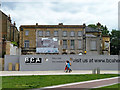
Site for Black Cultural Archives Centre
Since completed and opened.
Image: © Robin Webster
Taken: 23 Jul 2011
0.03 miles
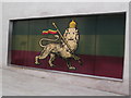
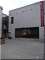
2
Exhibition logo, Black Cultural Archives, Windrush Square SW9
Image: © Robin Sones
Taken: 4 Sep 2016
0.03 miles
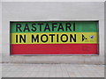
3
Rastafari In Motion Exhibition, Black Cultural Archives SW9
Image: © Robin Sones
Taken: 4 Sep 2016
0.03 miles
4
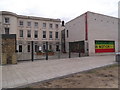
The Black Cultural Archives, Windrush Square SW9
Image: © Robin Sones
Taken: 4 Sep 2016
0.03 miles
5
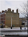
Ghost-sign, Brixton
A ghost-sign and, in the foreground, a stink-pipe: my cup runneth over.
Image: © Christopher Hilton
Taken: 21 Jan 2013
0.04 miles
6
Black Cultural Archives, Windrush Square SW9
Image: © Robin Sones
Taken: 4 Sep 2016
0.04 miles
7
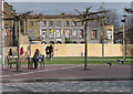
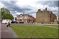
1-3 Effra Road
Aka Effra House and Raleigh Hall. A pair of villas dating from 1824, but now in a sorry state and on English Heritage's Heritage at Risk Register. Permission has been granted for conversion to a cultural centre, but nothing appears to have happened. It's a pity a hoarding has recently been erected as it blocks the view of the arched ground floor windows. Grade II listed.
The woman sitting down couldn't have got out of shot if she'd wanted as the seats are fixed to the ground. Together with pretty much everything else in view here, they are part of a recent landscaping of the area. Perhaps word had got out that there was a spot where it was possible to take a photo without any clutter obstructing the view.
Image: © Stephen Richards
Taken: 6 Mar 2011
0.04 miles
8
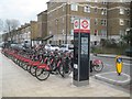
Brixton: Saltoun Road Santander Cycles docking station
At the time of this contribution Transport for London stated that there were more than 11,500 bikes at over 750 docking stations across London. This one is situated at a south-eastern corner of the area covered by the scheme. All the adjacent docking stations are in the quadrant to the north-west of here.
Image: © Nigel Cox
Taken: 14 Dec 2018
0.04 miles
9
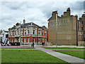
Towards Rushcroft Road
A large Bovril sign is visible on the end of the buildings and a mobile police station.
Image: © DS Pugh
Taken: 22 May 2016
0.05 miles
10
Tate Library and a wall, Brixton
'BOVRIL' remains clear on the wall, but something else in blue lower down has been partly removed by later events.
Image: © Robin Webster
Taken: 23 Jul 2011
0.05 miles