IMAGES TAKEN NEAR TO
Dalberg Road, LONDON, SW2 1AL
Introduction
This page details the photographs taken nearby to Dalberg Road, SW2 1AL by members of the Geograph project.
The Geograph project started in 2005 with the aim of publishing, organising and preserving representative images for every square kilometre of Great Britain, Ireland and the Isle of Man.

There are currently over 7.5m images from over14,400 individuals and you can help contribute to the project by visiting https://www.geograph.org.uk
Image Map
Images are licensed for reuse under creativecommons.org/licenses/by-sa/2.0
Notes
- Clicking on the map will re-center to the selected point.
- The higher the marker number, the further away the image location is from the centre of the postcode.
Image Listing (60 Images Found)
Images are licensed for reuse under creativecommons.org/licenses/by-sa/2.0
Image
Details
Distance
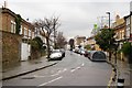
1
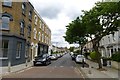
Barnwell Road
From the junction with Rattray Road.
Image: © DS Pugh
Taken: 22 May 2016
0.05 miles
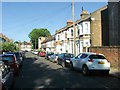
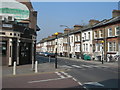
2
Effra Parade, SW2
Near the corner of Dulwich Road, looking towards Railton Road http://www.geograph.org.uk/photo/380918
Image: © Danny P Robinson
Taken: 27 Mar 2007
0.08 miles
3
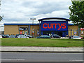
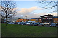
Currys, Brixton
In a retail park off Elfra Road.
Image: © Robin Webster
Taken: 23 Jul 2011
0.11 miles
4
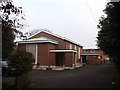
Effra Road Chapel, Brixton
Effra Road.
Unitarian Libral Christian Church, founded in 1839.
Image: © David Anstiss
Taken: 20 Nov 2011
0.11 miles
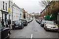
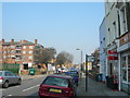
8
Effra Road
Looking along Effra Road near Crownstone Road.
Image: © DS Pugh
Taken: 22 May 2016
0.12 miles
9
Effra Road Retail Park
A small retail park near the centre of Brixton.
Image: © Bill Boaden
Taken: 1 Feb 2014
0.13 miles
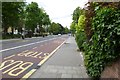
10
Railton Road, SE24
At the corner of Effra Parade (which falls into the SW2 postcode area).
Image: © Danny P Robinson
Taken: 27 Mar 2007
0.13 miles