IMAGES TAKEN NEAR TO
Southdown Road, LONDON, SW20 8PT
Introduction
This page details the photographs taken nearby to Southdown Road, SW20 8PT by members of the Geograph project.
The Geograph project started in 2005 with the aim of publishing, organising and preserving representative images for every square kilometre of Great Britain, Ireland and the Isle of Man.

There are currently over 7.5m images from over14,400 individuals and you can help contribute to the project by visiting https://www.geograph.org.uk
Image Map
Images are licensed for reuse under creativecommons.org/licenses/by-sa/2.0
Notes
- Clicking on the map will re-center to the selected point.
- The higher the marker number, the further away the image location is from the centre of the postcode.
Image Listing (17 Images Found)
Images are licensed for reuse under creativecommons.org/licenses/by-sa/2.0
Image
Details
Distance
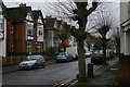
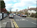
2
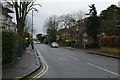
Ethelbert Road, Wimbledon
Part of a large area of private housing.
Image: © G Laird
Taken: 5 Jul 2012
0.04 miles
4
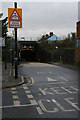
Low railway bridge over Lower Downs Road
Image: © Christopher Hilton
Taken: 26 Jan 2015
0.05 miles
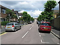
5
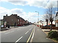
Looking down Worple Road towards Raynes Park, at Lower Downs Road
Image: © Christopher Hilton
Taken: 26 Jan 2015
0.09 miles
6
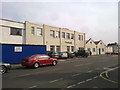
Dundonald Church
This was a church plant from the C of E in Wimbledon. It meets in a former printing works.
Image: © Bill Boaden
Taken: 15 Aug 2010
0.12 miles
8
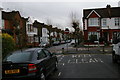
View down Pentney Road into Southdown Road, Wimbledon
Image: © Christopher Hilton
Taken: 26 Jan 2015
0.15 miles
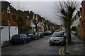
10
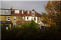
Housing in Midmoor Road, Wimbledon
Image: © Mike Pennington
Taken: 14 Nov 2017
0.16 miles