IMAGES TAKEN NEAR TO
Lindisfarne Road, LONDON, SW20 0NW
Introduction
This page details the photographs taken nearby to Lindisfarne Road, SW20 0NW by members of the Geograph project.
The Geograph project started in 2005 with the aim of publishing, organising and preserving representative images for every square kilometre of Great Britain, Ireland and the Isle of Man.

There are currently over 7.5m images from over14,400 individuals and you can help contribute to the project by visiting https://www.geograph.org.uk
Image Map (Loading...)


Getting Data...Please wait
Leaflet Map data © OpenStreetMap
Images are licensed for reuse under creativecommons.org/licenses/by-sa/2.0
Notes
- Clicking on the map will re-center to the selected point.
- The higher the marker number, the further away the image location is from the centre of the postcode.
Image Listing (31 Images Found)
Images are licensed for reuse under creativecommons.org/licenses/by-sa/2.0
Image
Details
Distance
1
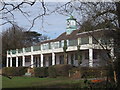
Oberon Pavilion, Cottenham Park
This cricket pavilion is on Lindisfarne Road.
This is used by the Old Wimbledonians (former pupils of Wimbledon College).
Image: © David Anstiss
Taken: 14 Apr 2013
0.05 miles
2
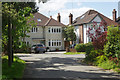
Lindisfarne Road, Copse Hill
This is affluent suburbia, with large detached houses on a cul-de-sac off Copse Hill close to Wimbledon Common and every other sort of amenity. Needless to say the properties here are not cheap.
Image: © Stephen McKay
Taken: 10 May 2018
0.05 miles
3
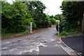
Almer Road
This is a private road running off Copse Hill.
Image: © Bill Boaden
Taken: 14 Aug 2010
0.10 miles
4
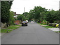
Drax Avenue, West Wimbledon
An avenue of private houses running parallel to Copse Hill.
Image: © G Laird
Taken: 5 Jul 2012
0.14 miles
5
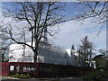
Wimbledon Hill Park development
This large building site (and tower crane) is on Copse Hill.
The development is part of the conversion of the former Atkinson Morley Hospital (AMH). The last section of the hospital was closed in 2012.
Image: © David Anstiss
Taken: 14 Apr 2013
0.14 miles
6
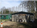
19th Wimbledon Scout Hut, Cottenham Park
This group of buildings is near Cottenham Park Road.
Image: © David Anstiss
Taken: 14 Apr 2013
0.14 miles
7
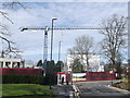
Tower Crane on Copse Hill
This large building site (and tower crane) is on Copse Hill.
The development is part of the conversion of the former Atkinson Morley Hospital (AMH). The last section of the hospital was closed in 2012.
In the foreground, is a bus stop on Atkinson close, used by the No.200 Bus between Mitcham and Raynes Park.
Image: © David Anstiss
Taken: 14 Apr 2013
0.15 miles
8
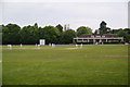
Village cricket in Cottenham Park
The markings of the football pitches are still very clear.
Image: © Bill Boaden
Taken: 7 May 2011
0.15 miles
9

New bus stop, Copse Hill
Not yet open and surrounded by screens, this stop is somewhat west of the current stop for route 200. Both are turn round stops, the bus departing the way it came. Repositioning is consequent to the redevelopment of the old hospital site.
Image: © Robin Webster
Taken: 12 May 2012
0.15 miles
10
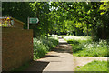
Footpath in Cottenham Park
With an abundance of flowering cow parsley, this path looks more rural than it really is. It passes between a school playing field and allotment gardens linking two sections of Cottenham Park Road. The path signposted to the right leads to Lindisfarne Road.
Image: © Stephen McKay
Taken: 10 May 2018
0.15 miles