IMAGES TAKEN NEAR TO
Milton Road, LONDON, SW19 8SF
Introduction
This page details the photographs taken nearby to Milton Road, SW19 8SF by members of the Geograph project.
The Geograph project started in 2005 with the aim of publishing, organising and preserving representative images for every square kilometre of Great Britain, Ireland and the Isle of Man.

There are currently over 7.5m images from over14,400 individuals and you can help contribute to the project by visiting https://www.geograph.org.uk
Image Map
Images are licensed for reuse under creativecommons.org/licenses/by-sa/2.0
Notes
- Clicking on the map will re-center to the selected point.
- The higher the marker number, the further away the image location is from the centre of the postcode.
Image Listing (66 Images Found)
Images are licensed for reuse under creativecommons.org/licenses/by-sa/2.0
Image
Details
Distance
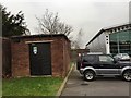
1
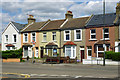
Milton Road bus stop
The southbound stop on Haydon's Road. Also a useful colour chart for your external paint.
Image: © Robin Webster
Taken: 12 May 2012
0.06 miles
2
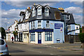
233 Haydons Road, SW19
The corner premises are currently vacant. More recently trading from here were Curry Inn take-away, and presumably at different recent times, Grand Taj take-away and Buffalo Pizza.
Image: © Robin Webster
Taken: 12 May 2012
0.07 miles
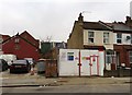
3
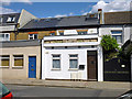
241 Haydons Road, SW19
The missing fascia boards have revealed an earlier life as probably an off-licence - it seems too small to have been a pub, and has never been mapped as such.
Image: © Robin Webster
Taken: 12 May 2012
0.07 miles
5
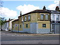
Formerly something on the corner
Now apparently residential, entered from the back, this looks a little too grand to have been just a shop, yet it was never a pub according to maps.
Image: © Robin Webster
Taken: 12 May 2012
0.10 miles
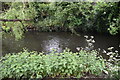
7
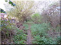
South Wimbledon, riverside walk
Along River Wandle.
Image: © Mike Faherty
Taken: 23 Nov 2013
0.13 miles
8
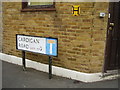
OS Bench Mark, Cardigan Road
The OS Database records this as Haydons Road.
Image: © Anthony Vosper
Taken: 22 Apr 2016
0.13 miles