IMAGES TAKEN NEAR TO
Virginia Mews, SW19 8NH
Introduction
This page details the photographs taken nearby to Virginia Mews, SW19 8NH by members of the Geograph project.
The Geograph project started in 2005 with the aim of publishing, organising and preserving representative images for every square kilometre of Great Britain, Ireland and the Isle of Man.

There are currently over 7.5m images from over14,400 individuals and you can help contribute to the project by visiting https://www.geograph.org.uk
Image Map
Images are licensed for reuse under creativecommons.org/licenses/by-sa/2.0
Notes
- Clicking on the map will re-center to the selected point.
- The higher the marker number, the further away the image location is from the centre of the postcode.
Image Listing (50 Images Found)
Images are licensed for reuse under creativecommons.org/licenses/by-sa/2.0
Image
Details
Distance
1
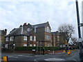
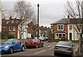
Priory Church Primary School, Wimbledon (2)
On the junction of Queen's Road (on the right) and Craven Gardens.
Image: © David Anstiss
Taken: 13 Jan 2013
0.06 miles
2
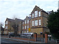
Priory Church Primary School, Wimbledon
On the junction of Queen's Road (in front) and Craven Gardens.
Image: © David Anstiss
Taken: 13 Jan 2013
0.07 miles
3
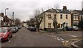
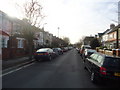
Birkbeck Road / Faraday Road, South Wimbledon
Birkbeck Road is to the left; at the end it meets Effra Road at a T-junction.
Image: © Derek Harper
Taken: 7 Feb 2010
0.09 miles
6
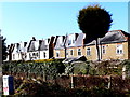
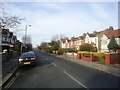
Houses In Cromwell Rd
This is the back of the houses that are on the north side of the railway track running from Haydons Rd Station to Wimbledon station which is less than a kilometre to the south west.
Image: © Nigel Mykura
Taken: 5 Mar 2013
0.12 miles
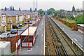
7
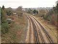
Railway line, Haydon's Road
The line, originally the Tooting, Merton & Wimbledon Railway, west of the station and seen from the bridge on Haydon's Road. It runs along the rear of properties on Queen's Road (left) and Cromwell Road (right).
Image: © Derek Harper
Taken: 7 Feb 2010
0.12 miles
8
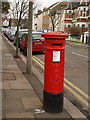
Pillar box, Effra Road
The Edward VII postbox, number SW19 81. is almost at the corner with Birkbeck Road, and its top can be espied left of centre in Image
Image: © Derek Harper
Taken: 7 Feb 2010
0.13 miles
9
Junctions on Effra Road, South Wimbledon
Seen from Birkbeck Road. The road not quite opposite is Edith Road.
Image: © Derek Harper
Taken: 7 Feb 2010
0.13 miles
10
Haydons Road station, 1992
View eastward, towards Tooting, Streatham and London (Blackfriars) etc.: ex-LSW&LBSC Joint Streatham Junction - Wimbledon line. Until 1987 ex-SR trains ran Holborn Viaduct - Wimbledon - Sutton; subsequently they have been Thameslink trains from Bedford etc. via Farringdon and Blackfriars - Sutton.
Image: © Ben Brooksbank
Taken: 11 Oct 1992
0.14 miles