IMAGES TAKEN NEAR TO
Plough Lane, LONDON, SW19 8HA
Introduction
This page details the photographs taken nearby to Plough Lane, SW19 8HA by members of the Geograph project.
The Geograph project started in 2005 with the aim of publishing, organising and preserving representative images for every square kilometre of Great Britain, Ireland and the Isle of Man.

There are currently over 7.5m images from over14,400 individuals and you can help contribute to the project by visiting https://www.geograph.org.uk
Image Map
Images are licensed for reuse under creativecommons.org/licenses/by-sa/2.0
Notes
- Clicking on the map will re-center to the selected point.
- The higher the marker number, the further away the image location is from the centre of the postcode.
Image Listing (95 Images Found)
Images are licensed for reuse under creativecommons.org/licenses/by-sa/2.0
Image
Details
Distance
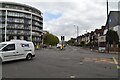
2
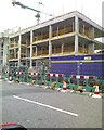
Wimbledon FC (former), SW19
On the corner of Plough Lane and Durnsford Road is the old site of Wimbledon Football Club demolished in 2002 and now turned into a mini housing estate.
Image: © Phillip Perry
Taken: Unknown
0.04 miles
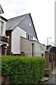
3
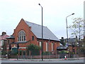
Kingdom Hall near Wimbledon
Kingdom Hall of Jehovah's Witnesses on the corner of Plough Lane and Haydons Road, near Wimbledon.
Image: © Malc McDonald
Taken: 13 Nov 2010
0.04 miles
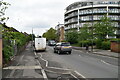
4
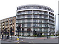
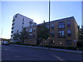
Apartments near Wimbledon
An apartment block built on the site of the former Wimbledon football ground.
Image: © Malc McDonald
Taken: 13 Nov 2010
0.04 miles
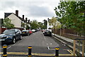
5
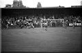
Plough Lane - The former home of Wimbledon FC
Image: © Steve Daniels
Taken: 20 Apr 1982
0.04 miles
7
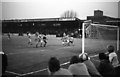
Plough Lane - The former home of Wimbledon FC
Image: © Steve Daniels
Taken: 20 Apr 1982
0.06 miles