IMAGES TAKEN NEAR TO
Gresham Way, LONDON, SW19 8DW
Introduction
This page details the photographs taken nearby to Gresham Way, SW19 8DW by members of the Geograph project.
The Geograph project started in 2005 with the aim of publishing, organising and preserving representative images for every square kilometre of Great Britain, Ireland and the Isle of Man.

There are currently over 7.5m images from over14,400 individuals and you can help contribute to the project by visiting https://www.geograph.org.uk
Image Map (Loading...)


Getting Data...Please wait
Leaflet Map data © OpenStreetMap
Images are licensed for reuse under creativecommons.org/licenses/by-sa/2.0
Notes
- Clicking on the map will re-center to the selected point.
- The higher the marker number, the further away the image location is from the centre of the postcode.
Image Listing (87 Images Found)
Images are licensed for reuse under creativecommons.org/licenses/by-sa/2.0
Image
Details
Distance

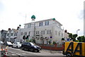
3
Southfields Mosque
This side of the mosque faces Durnsford Road. See also Image
Image: © Stephen Craven
Taken: 8 Apr 2011
0.04 miles
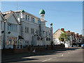
4

Southfields Mosque, Ryfold Road
The northern side of the mosque. See also Image
Image: © Stephen Craven
Taken: 8 Apr 2011
0.04 miles
5
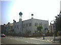
Southfields Mosque, Durnsford Road.
Corner of Ryfold Road.
Image: © Noel Foster
Taken: 24 Jun 2005
0.05 miles
6
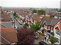
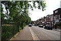
Strathmore Road
Elevated view of street and suburbia.
Image: © Ian Paterson
Taken: 13 May 2009
0.05 miles
7
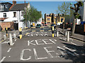
Traffic barrier on Ryfold Road
This barrier - with marked cycle lanes either side - is to prevent motorised traffic getting into or out of Ryfold Road from Durnsford Road.
Image: © Stephen Craven
Taken: 8 Apr 2011
0.06 miles
8
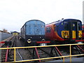
Sidings and carriages, Wimbledon traincare depot
The colourful carriage (on the right) belongs to South West Trains.
They runs these trains from Waterloo to Guildford via Epsom.
Image: © David Anstiss
Taken: 13 Jan 2013
0.07 miles
10
St Luke's hall, Strathmore Road
The hall is adjacent to the church to which it relates Image
Image: © Stephen Craven
Taken: 8 Apr 2011
0.08 miles