IMAGES TAKEN NEAR TO
Dora Road, LONDON, SW19 7HH
Introduction
This page details the photographs taken nearby to Dora Road, SW19 7HH by members of the Geograph project.
The Geograph project started in 2005 with the aim of publishing, organising and preserving representative images for every square kilometre of Great Britain, Ireland and the Isle of Man.

There are currently over 7.5m images from over14,400 individuals and you can help contribute to the project by visiting https://www.geograph.org.uk
Image Map (Loading...)


Getting Data...Please wait
Leaflet Map data © OpenStreetMap
Images are licensed for reuse under creativecommons.org/licenses/by-sa/2.0
Notes
- Clicking on the map will re-center to the selected point.
- The higher the marker number, the further away the image location is from the centre of the postcode.
Image Listing (73 Images Found)
Images are licensed for reuse under creativecommons.org/licenses/by-sa/2.0
Image
Details
Distance
2
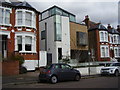
Interesting infill
A modern house stands in between terraces of Victorian houses.
The numbers are consistent. One could speculate the original could have fallen victim of the blitz.
Image: © Anthony Vosper
Taken: 23 Apr 2016
0.04 miles

5
House on the corner, Wimbledon
The end house of a row of four similar double-fronted houses on Vineyard Hill Road.
Image: © Robin Webster
Taken: 14 Apr 2012
0.08 miles
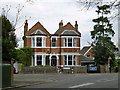
7
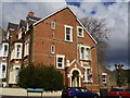
House on the corner
A grand late Victorian house on the corner of Kenilworth Avenue and Leopold Road.
Prince Leopold was the 4th son of Queen Victoria.
Image: © Anthony Vosper
Taken: 23 Apr 2016
0.09 miles