IMAGES TAKEN NEAR TO
Arthur Road, LONDON, SW19 7DR
Introduction
This page details the photographs taken nearby to Arthur Road, SW19 7DR by members of the Geograph project.
The Geograph project started in 2005 with the aim of publishing, organising and preserving representative images for every square kilometre of Great Britain, Ireland and the Isle of Man.

There are currently over 7.5m images from over14,400 individuals and you can help contribute to the project by visiting https://www.geograph.org.uk
Image Map
Images are licensed for reuse under creativecommons.org/licenses/by-sa/2.0
Notes
- Clicking on the map will re-center to the selected point.
- The higher the marker number, the further away the image location is from the centre of the postcode.
Image Listing (100 Images Found)
Images are licensed for reuse under creativecommons.org/licenses/by-sa/2.0
Image
Details
Distance
1
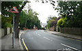
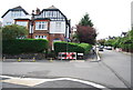
Arthur Road - Steep Hill 10%
Arthur Road, Wimbledon. 10% steep hill down sign.
Image: © Adam Morse
Taken: 4 Aug 2009
0.03 miles
2
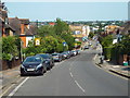
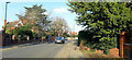
Arthur Road, near Wimbledon
A view down Arthur Road, looking eastwards over the suburbs of south London.
Image: © Malc McDonald
Taken: 1 Jul 2018
0.04 miles

5
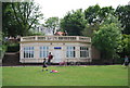
Police station, Wimbledon Park
Rather unusual - the roof forms a publicly accessible platform.
Image: © Robin Webster
Taken: 14 Apr 2012
0.08 miles
6
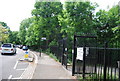
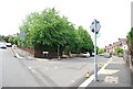
Arthur Road, Wimbledon, 2
A quiet residential street, looking towards Wandsworth.
Image: © Jonathan Billinger
Taken: 1 Dec 2020
0.08 miles
10
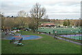
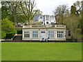
Wimbledon Park
Some of the LTA courts, close to the All England Club.
Image: © Peter Trimming
Taken: 30 Dec 2024
0.10 miles