IMAGES TAKEN NEAR TO
Frimley Close, LONDON, SW19 6QD
Introduction
This page details the photographs taken nearby to Frimley Close, SW19 6QD by members of the Geograph project.
The Geograph project started in 2005 with the aim of publishing, organising and preserving representative images for every square kilometre of Great Britain, Ireland and the Isle of Man.

There are currently over 7.5m images from over14,400 individuals and you can help contribute to the project by visiting https://www.geograph.org.uk
Image Map (Loading...)


Getting Data...Please wait
Leaflet Map data © OpenStreetMap
Images are licensed for reuse under creativecommons.org/licenses/by-sa/2.0
Notes
- Clicking on the map will re-center to the selected point.
- The higher the marker number, the further away the image location is from the centre of the postcode.
Image Listing (51 Images Found)
Images are licensed for reuse under creativecommons.org/licenses/by-sa/2.0
Image
Details
Distance
1
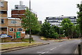
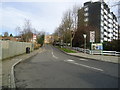
Frimley Close Estate
Wandsworth Council housing on Victoria Drive.
Image: © Bill Boaden
Taken: 7 May 2011
0.06 miles
2
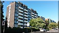
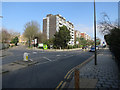
Blocks of flats overlooking Wimbledon Park
Image: © David Martin
Taken: 3 Oct 2016
0.07 miles
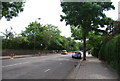
9
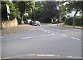
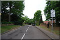
Princes Way at the junction of Woodspring Road
We are now in one of the best parts of both Wimbledon and London, although since it was built they added many large estates of council flats between the existing houses. That is a very unusual policy.
Image: © David Howard
Taken: 4 Aug 2014
0.10 miles
10
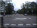
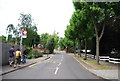
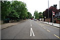
Mini roundabout on Wimbledon Park Road
Image: © David Howard
Taken: 31 Aug 2008
0.10 miles