IMAGES TAKEN NEAR TO
Parkside, LONDON, SW19 5NJ
Introduction
This page details the photographs taken nearby to Parkside, SW19 5NJ by members of the Geograph project.
The Geograph project started in 2005 with the aim of publishing, organising and preserving representative images for every square kilometre of Great Britain, Ireland and the Isle of Man.

There are currently over 7.5m images from over14,400 individuals and you can help contribute to the project by visiting https://www.geograph.org.uk
Image Map
Images are licensed for reuse under creativecommons.org/licenses/by-sa/2.0
Notes
- Clicking on the map will re-center to the selected point.
- The higher the marker number, the further away the image location is from the centre of the postcode.
Image Listing (35 Images Found)
Images are licensed for reuse under creativecommons.org/licenses/by-sa/2.0
Image
Details
Distance
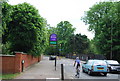
1
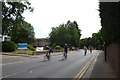
Cyclists on Parkside
Cyclists completing the 2015 Ride London descend Parkside.
Image: © DS Pugh
Taken: 2 Aug 2015
0.04 miles
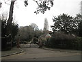
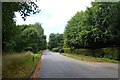
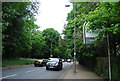
2
Wimbledon Parkside (A219), looking north
The road emerging on the right is Alfreton Close
Image: © Dr Neil Clifton
Taken: 25 Jun 2013
0.06 miles
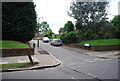
4
Windmill Road
Looking along Windmill Road from Parkside.
Image: © DS Pugh
Taken: 2 Aug 2015
0.08 miles
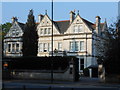
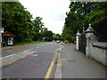
8
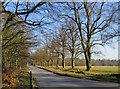
Windmill Road in February
Looking east towards Parkside, with the Windmill itself behind the camera. The flat and open expanse to the south (right) of the road is known as the Plain.
Image: © Stefan Czapski
Taken: 19 Feb 2013
0.12 miles