IMAGES TAKEN NEAR TO
Parkside, LONDON, SW19 5NA
Introduction
This page details the photographs taken nearby to Parkside, SW19 5NA by members of the Geograph project.
The Geograph project started in 2005 with the aim of publishing, organising and preserving representative images for every square kilometre of Great Britain, Ireland and the Isle of Man.

There are currently over 7.5m images from over14,400 individuals and you can help contribute to the project by visiting https://www.geograph.org.uk
Image Map (Loading...)


Getting Data...Please wait
Leaflet Map data © OpenStreetMap
Images are licensed for reuse under creativecommons.org/licenses/by-sa/2.0
Notes
- Clicking on the map will re-center to the selected point.
- The higher the marker number, the further away the image location is from the centre of the postcode.
Image Listing (106 Images Found)
Images are licensed for reuse under creativecommons.org/licenses/by-sa/2.0
Image
Details
Distance
1
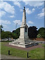
Wimbledon - War Memorial
To the men and women of Wimbledon who gave their lives in WW1, WW2, and other conflicts.
Image: © Peter Trimming
Taken: 4 Jun 2009
0.03 miles
2
War Memorial, Wimbledon Common
A war memorial on the edge of Wimbledon Common, in south west London.
Image: © Malc McDonald
Taken: 1 Jul 2018
0.05 miles
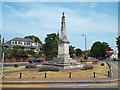
3
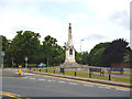
Wimbledon War Memorial
Very prominently placed on the edge of Wimbledon Common as one approaches from the High Street and Wimbledon Village, the war memorial is suitable large.
Image: © Marathon
Taken: 25 Jul 2012
0.06 miles
4
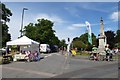
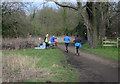
The Green
Looking along The Green onwards to Parkside. The cyclists and stalls are part of the 2015 Ride London cycling event.
Image: © DS Pugh
Taken: 2 Aug 2015
0.06 miles
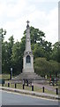
5
Wimbledon: War Memorial
On the edge of Wimbledon Common
Image: © Dr Neil Clifton
Taken: 27 Jun 2013
0.06 miles
6
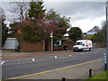
The village bus stop
High street. Wimbledon.
Whilst no longer a separate community this part of Wimbledon is still known as the village.
Image: © Anthony Vosper
Taken: 23 Apr 2016
0.06 miles
7
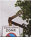
Old Direction Sign - Signpost on the A219 High Street Wimbledon
Lost finial - 3 arms; Surrey post by the A219, in parish of Wimbledon And Merton (Merton District), on the south side of the Y junction of the A219 High Street Wimbledon and the B281 Cannizaro Road.
surveyed
Milestone Society National ID: SY_TQ2371
Image: © Milestone Society
Taken: 8 May 2013
0.08 miles
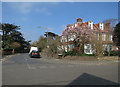
8
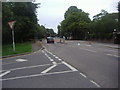
Wimbledon Parkside
At junction of Cannizaro Road.
Image: © David Howard
Taken: 27 Jun 2011
0.08 miles