IMAGES TAKEN NEAR TO
Haven Close, LONDON, SW19 5JW
Introduction
This page details the photographs taken nearby to Haven Close, SW19 5JW by members of the Geograph project.
The Geograph project started in 2005 with the aim of publishing, organising and preserving representative images for every square kilometre of Great Britain, Ireland and the Isle of Man.

There are currently over 7.5m images from over14,400 individuals and you can help contribute to the project by visiting https://www.geograph.org.uk
Image Map
Images are licensed for reuse under creativecommons.org/licenses/by-sa/2.0
Notes
- Clicking on the map will re-center to the selected point.
- The higher the marker number, the further away the image location is from the centre of the postcode.
Image Listing (32 Images Found)
Images are licensed for reuse under creativecommons.org/licenses/by-sa/2.0
Image
Details
Distance
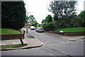
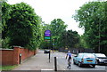
4
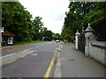
Wimbledon Parkside (A219), looking north
The road emerging on the right is Alfreton Close
Image: © Dr Neil Clifton
Taken: 25 Jun 2013
0.12 miles
5
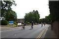
Cyclists on Parkside
Cyclists completing the 2015 Ride London descend Parkside.
Image: © DS Pugh
Taken: 2 Aug 2015
0.12 miles
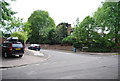
7
Apartments in Queensmere Road, Wimbledon
Near to Wimbledon Common
Image: © Paul Gillett
Taken: 11 Oct 2013
0.13 miles
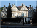
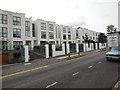
8
Southlands Drive
A gated estate of wealthy housing.
Image: © Des Blenkinsopp
Taken: 18 Feb 2015
0.14 miles
10
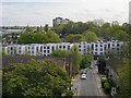
View from Glen Albyn Road
View from a third-floor balcony, along Thursley Gardens to Queensmere Road.
Details which might easily go unnoticed are the grey stone gables of the former Southlands College - visible just behind the left-hand end of the white-painted buildings in Queensmere Road.
I have known this area for more than half a century, during which time it has been developed at far greater residential density. The original Victorian settlement was quite sparse - grand houses along just a few roads, like Albert Drive and Inner Park Road. Development in the 1920's and '30's took the form of smaller - but still substantial - properties along Bathgate Road, Victoria Drive, Princes Way and elsewhere. In the 1950's and '60's grand houses, stables and orchards gave way to extensive local authority housing. Glen Albyn Road was laid out by Wandsworth Borough Council at that time. Thursley Gardens is one of many smaller streets that arose in later years as residential in-filling took place.
Image: © Stefan Czapski
Taken: 1 May 2015
0.15 miles