IMAGES TAKEN NEAR TO
Lincoln Avenue, LONDON, SW19 5JT
Introduction
This page details the photographs taken nearby to Lincoln Avenue, SW19 5JT by members of the Geograph project.
The Geograph project started in 2005 with the aim of publishing, organising and preserving representative images for every square kilometre of Great Britain, Ireland and the Isle of Man.

There are currently over 7.5m images from over14,400 individuals and you can help contribute to the project by visiting https://www.geograph.org.uk
Image Map (Loading...)


Getting Data...Please wait
Leaflet Map data © OpenStreetMap
Images are licensed for reuse under creativecommons.org/licenses/by-sa/2.0
Notes
- Clicking on the map will re-center to the selected point.
- The higher the marker number, the further away the image location is from the centre of the postcode.
Image Listing (23 Images Found)
Images are licensed for reuse under creativecommons.org/licenses/by-sa/2.0
Image
Details
Distance
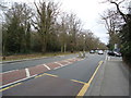
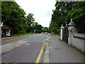
5
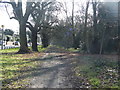
Parkside footpath
Footpath running north-south along Parkside (A219) on the eastern edge of Wimbledon Common. Also known as "Pertinax Path".
Image: © PhotoMan9000
Taken: 1 Jan 2014
0.10 miles
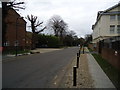
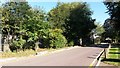
8

Parkside, Wimbledon
Parkside, part of the A219, runs along the eastern edge of Wimbledon Common. This view shows its junction with Somerset Road.
Image: © Stephen McKay
Taken: 5 Aug 2019
0.11 miles
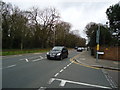
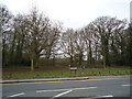
9
Wimbledon Parkside (A219), looking north
The road emerging on the right is Alfreton Close
Image: © Dr Neil Clifton
Taken: 25 Jun 2013
0.14 miles