IMAGES TAKEN NEAR TO
Lampton House Close, LONDON, SW19 5EX
Introduction
This page details the photographs taken nearby to Lampton House Close, SW19 5EX by members of the Geograph project.
The Geograph project started in 2005 with the aim of publishing, organising and preserving representative images for every square kilometre of Great Britain, Ireland and the Isle of Man.

There are currently over 7.5m images from over14,400 individuals and you can help contribute to the project by visiting https://www.geograph.org.uk
Image Map (Loading...)


Getting Data...Please wait
Leaflet Map data © OpenStreetMap
Images are licensed for reuse under creativecommons.org/licenses/by-sa/2.0
Notes
- Clicking on the map will re-center to the selected point.
- The higher the marker number, the further away the image location is from the centre of the postcode.
Image Listing (41 Images Found)
Images are licensed for reuse under creativecommons.org/licenses/by-sa/2.0
Image
Details
Distance
1
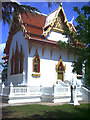
Buddhapadipa Temple, Calonne Road, Wimbledon.
Buddhist Temple.
Image: © Noel Foster
Taken: 18 Jun 2005
0.07 miles
2

Buddhapadipa Temple, Wimbledon, SW19
Built in 1980, using traditional Thai architecture, for the purpose of teaching Theravada Buddhism, the Buddhapadipa Temple is a complex of buildings set in four acres of parkland and is one of only two outside Asia. The interior walls have excellent mural paintings by Thai artists, depicting aspects of the Buddha's life.
(Thanks to LB of Merton website:
http://www.merton.gov.uk/leisure/history-heritage/architecture/open_house_buddhapadipa_temple.htm )
Image: © Phillip Perry
Taken: 12 Jul 2007
0.07 miles
3
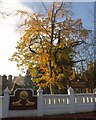
Buddhapadipa Temple, Wimbledon
Just a glimpse of this wonder of Wimbledon behind a fine autumnal beech and other, associated buildings. See also Image The designer of Wat Buddhapadipa was Praves Limparasangsri. http://www.buddhapadipa.org/pages/temple.html
Image: © Derek Harper
Taken: 16 Nov 2010
0.11 miles
4
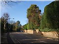
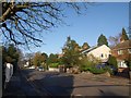
Calonne Road, Wimbledon
Image: © Derek Harper
Taken: 16 Nov 2010
0.13 miles
5
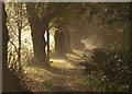
Nurses' Walk
Another view along the misty path shown in Image, separated from Parkside by stout trees.
Image: © Derek Harper
Taken: 16 Nov 2010
0.14 miles
6
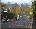
Calonne Road, Wimbledon
The road shown in Image has climbed to the plateau of Wimbledon Common and levelled out
Image: © Derek Harper
Taken: 16 Nov 2010
0.16 miles
7
Basement work on Marryat Road
Expanding downwards is now a common process in London.
Image: © Hugh Venables
Taken: 13 Mar 2016
0.17 miles
8
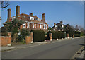
Burghley Road, Wimbledon
Leafy suburbia. The road swoops down from the crossroads with Marryat Road, before climbing towards Wimbledon Common.
Image: © Derek Harper
Taken: 16 Nov 2010
0.17 miles
10
Old Direction Sign - Signpost on the A219 High Street Wimbledon
Lost finial - 3 arms; Surrey post by the A219, in parish of Wimbledon And Merton (Merton District), on the south side of the Y junction of the A219 High Street Wimbledon and the B281 Cannizaro Road.
surveyed
Milestone Society National ID: SY_TQ2371
Image: © Milestone Society
Taken: 8 May 2013
0.17 miles