IMAGES TAKEN NEAR TO
Burghley Road, LONDON, SW19 5BG
Introduction
This page details the photographs taken nearby to Burghley Road, SW19 5BG by members of the Geograph project.
The Geograph project started in 2005 with the aim of publishing, organising and preserving representative images for every square kilometre of Great Britain, Ireland and the Isle of Man.

There are currently over 7.5m images from over14,400 individuals and you can help contribute to the project by visiting https://www.geograph.org.uk
Image Map
Images are licensed for reuse under creativecommons.org/licenses/by-sa/2.0
Notes
- Clicking on the map will re-center to the selected point.
- The higher the marker number, the further away the image location is from the centre of the postcode.
Image Listing (133 Images Found)
Images are licensed for reuse under creativecommons.org/licenses/by-sa/2.0
Image
Details
Distance
1
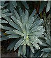
Spurge, Dairy Walk
Frost has melted to forms water drops on the silky leaves of this Euphorbia, by the eastern end of the footpath that runs parallel to Burghley Road.
Image: © Derek Harper
Taken: 16 Nov 2010
0.06 miles
2
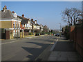
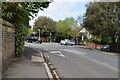
Approaching the crossroads of Marryat and Burghley Roads
Image: © Basher Eyre
Taken: 2 Jul 2012
0.08 miles
4
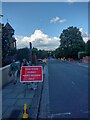
Mayfield Road closed for the Tennis
Mayfield Road is only open for residents and permit holders for the duration of the Wimbledon Tennis championships, with The City in the background.
Image: © Martyn Pattison
Taken: 30 Jun 2022
0.09 miles
5
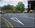
Stop
Police control the junction on Church Hill as people and traffic leave the tennis.
Image: © Steve Fareham
Taken: 27 Jun 2009
0.09 miles
6
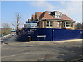
Marryat Place
New houses by Marryat Road.
Image: © Hugh Venables
Taken: 13 Mar 2016
0.10 miles
7
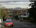
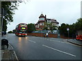
View from Wimbledon
Seen from Marryat Road. The All England Club is in the foreground, at the bottom of the road, with the City of London in the distance.
Image: © Peter Trimming
Taken: 30 Dec 2024
0.10 miles
8
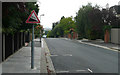
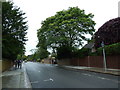
Marryat Road - Steep Hill 10%
Marryat Road, Wimbledon. 10% steep hill down sign.
Image: © Adam Morse
Taken: 4 Aug 2009
0.10 miles