IMAGES TAKEN NEAR TO
Worple Road, LONDON, SW19 4LB
Introduction
This page details the photographs taken nearby to Worple Road, SW19 4LB by members of the Geograph project.
The Geograph project started in 2005 with the aim of publishing, organising and preserving representative images for every square kilometre of Great Britain, Ireland and the Isle of Man.

There are currently over 7.5m images from over14,400 individuals and you can help contribute to the project by visiting https://www.geograph.org.uk
Image Map
Images are licensed for reuse under creativecommons.org/licenses/by-sa/2.0
Notes
- Clicking on the map will re-center to the selected point.
- The higher the marker number, the further away the image location is from the centre of the postcode.
Image Listing (50 Images Found)
Images are licensed for reuse under creativecommons.org/licenses/by-sa/2.0
Image
Details
Distance
1
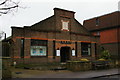
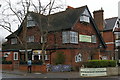
Christian Science church, Worple Road, Wimbledon
Image: © Christopher Hilton
Taken: 26 Jan 2015
0.02 miles
2
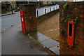
Post box and defunct stamp machine, bottom of Spencer Hill
Image: © Christopher Hilton
Taken: 26 Jan 2015
0.02 miles
3
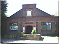
Christian Science Church, Worple Road, Wimbledon.
It's that tiny cross at TQ244704 on the North side of the B235.
Image: © Noel Foster
Taken: 18 Jun 2005
0.03 miles
4
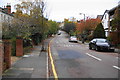
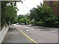
Spencer Hill, Wimbledon
Along the ridge from Wimbledon Hill, it has a surprising gradient in this residential area.
Image: © Bill Boaden
Taken: 13 Nov 2010
0.04 miles
5
Justin James Hotel and Lu-Ma Healthy Living Caf?, Worple Road, Wimbledon
Image: © Christopher Hilton
Taken: 26 Jan 2015
0.10 miles
6
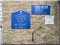
St Mark, St Mark's Place, Wimbledon - Notice board
Image: © John Salmon
Taken: 9 Mar 2018
0.10 miles
8
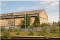
The Old Aircraft Hangar in Wimbledon West Goods Yard, Dundonald Road
This large building was originally a seaplane hangar at Newhaven in Sussex during the First World War.
The Royal Naval Airstation Newhaven was built in 1917. The base was used by seaplanes to carry out anti U-boat patrols and escort convoys moving in the Channel. Newhaven and Littlehampton were the main ports for stores and munitions. This metal hangar was transported to the Railway yard at Wimbledon around 1923. Prior to being resited it was used as a factory to make concrete - hexagonal piles to repair Newhaven Pier. See: http://www.derelictlondon.com/war---bunkers-and-pillboxes.html
Image: © Chris
Taken: 17 Jul 2017
0.14 miles
9
Spencer Hill, Wimbledon
This road is deceptive: it is steeper than it looks in the photo, about 10%. The stepped wall at the left gives a better idea of the gradient.
Image: © Stephen Craven
Taken: 30 Jun 2010
0.14 miles
10
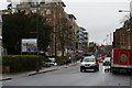
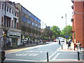
Worple Road, looking towards Wimbledon
Image: © Christopher Hilton
Taken: 26 Jan 2015
0.14 miles