IMAGES TAKEN NEAR TO
Raymond Road, LONDON, SW19 4AE
Introduction
This page details the photographs taken nearby to Raymond Road, SW19 4AE by members of the Geograph project.
The Geograph project started in 2005 with the aim of publishing, organising and preserving representative images for every square kilometre of Great Britain, Ireland and the Isle of Man.

There are currently over 7.5m images from over14,400 individuals and you can help contribute to the project by visiting https://www.geograph.org.uk
Image Map (Loading...)


Getting Data...Please wait
Leaflet Map data © OpenStreetMap
Images are licensed for reuse under creativecommons.org/licenses/by-sa/2.0
Notes
- Clicking on the map will re-center to the selected point.
- The higher the marker number, the further away the image location is from the centre of the postcode.
Image Listing (127 Images Found)
Images are licensed for reuse under creativecommons.org/licenses/by-sa/2.0
Image
Details
Distance
2
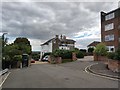
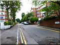
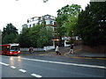
Sunnyside - Wimbledon
Residential cul-de-sac close to Wimbledon station.
Image: © James Emmans
Taken: 31 Aug 2020
0.08 miles

4
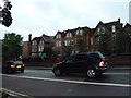
Looking across Wimbledon Hill Road towards Draxmont
Image: © Basher Eyre
Taken: 2 Jul 2012
0.09 miles
7
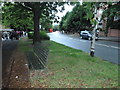
Belvedere Drive on a July evening in 2012
Image: © Basher Eyre
Taken: 2 Jul 2012
0.12 miles
8
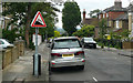
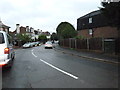
Ridgway Place - Steep Hill 10%
Ridgway Place, Wimbledon. 10% steep hill down sign.
Image: © Adam Morse
Taken: 4 Aug 2009
0.13 miles