IMAGES TAKEN NEAR TO
Erridge Road, LONDON, SW19 3JD
Introduction
This page details the photographs taken nearby to Erridge Road, SW19 3JD by members of the Geograph project.
The Geograph project started in 2005 with the aim of publishing, organising and preserving representative images for every square kilometre of Great Britain, Ireland and the Isle of Man.

There are currently over 7.5m images from over14,400 individuals and you can help contribute to the project by visiting https://www.geograph.org.uk
Image Map (Loading...)


Getting Data...Please wait
Leaflet Map data © OpenStreetMap
Images are licensed for reuse under creativecommons.org/licenses/by-sa/2.0
Notes
- Clicking on the map will re-center to the selected point.
- The higher the marker number, the further away the image location is from the centre of the postcode.
Image Listing (71 Images Found)
Images are licensed for reuse under creativecommons.org/licenses/by-sa/2.0
Image
Details
Distance
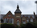
1
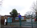
Merton Park Primary School: early February 2018
Image: © Basher Eyre
Taken: 3 Feb 2018
0.06 miles
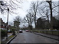
2
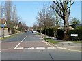
Poplar Road
A sports ground is on the right.
Image: © Robin Webster
Taken: 1 Apr 2012
0.07 miles
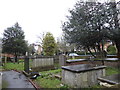
4
Former school opposite St Mary's Church
(now flats)
Image: © Basher Eyre
Taken: 3 Feb 2018
0.10 miles