IMAGES TAKEN NEAR TO
Melrose Road, LONDON, SW19 3HG
Introduction
This page details the photographs taken nearby to Melrose Road, SW19 3HG by members of the Geograph project.
The Geograph project started in 2005 with the aim of publishing, organising and preserving representative images for every square kilometre of Great Britain, Ireland and the Isle of Man.

There are currently over 7.5m images from over14,400 individuals and you can help contribute to the project by visiting https://www.geograph.org.uk
Image Map
Images are licensed for reuse under creativecommons.org/licenses/by-sa/2.0
Notes
- Clicking on the map will re-center to the selected point.
- The higher the marker number, the further away the image location is from the centre of the postcode.
Image Listing (99 Images Found)
Images are licensed for reuse under creativecommons.org/licenses/by-sa/2.0
Image
Details
Distance
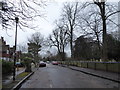
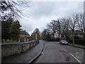
1
Looking east-northeast along Melrose Road
Image: © Basher Eyre
Taken: 3 Feb 2018
0.06 miles
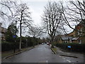
2
Looking north-northwest along Church Lane
Image: © Basher Eyre
Taken: 3 Feb 2018
0.07 miles
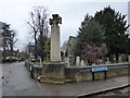
3
Looking northwards along Church Road towards a crossroads
Image: © Basher Eyre
Taken: 3 Feb 2018
0.08 miles
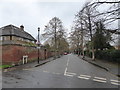
4
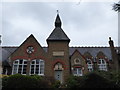
Former school opposite St Mary's Church
(now flats)
Image: © Basher Eyre
Taken: 3 Feb 2018
0.08 miles
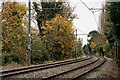
6
Tramlink
Trams passing to the east of Merton Park. The first and last trams of the current Tramlink fleet.
Image: © Peter Trimming
Taken: 16 Nov 2021
0.09 miles
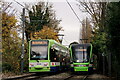
7
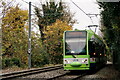
Tramlink
Wimbledon service approaching Merton Park.
Image: © Peter Trimming
Taken: 16 Nov 2021
0.09 miles