IMAGES TAKEN NEAR TO
Lyon Road, LONDON, SW19 2RU
Introduction
This page details the photographs taken nearby to Lyon Road, SW19 2RU by members of the Geograph project.
The Geograph project started in 2005 with the aim of publishing, organising and preserving representative images for every square kilometre of Great Britain, Ireland and the Isle of Man.

There are currently over 7.5m images from over14,400 individuals and you can help contribute to the project by visiting https://www.geograph.org.uk
Image Map
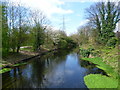
Images are licensed for reuse under creativecommons.org/licenses/by-sa/2.0
Notes
- Clicking on the map will re-center to the selected point.
- The higher the marker number, the further away the image location is from the centre of the postcode.
Image Listing (86 Images Found)
Images are licensed for reuse under creativecommons.org/licenses/by-sa/2.0
Image
Details
Distance
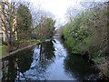
3

River Wandle at Merton Abbey Mills
Merton Abbey Mills are here on the left of the Wandle and the Wandle Trail is on the right. Just ahead on the left by the bend, the delightfully named Pickle Ditch leaves the Wandle to rejoin it at Merton High Street. Merton Abbey Mills dates originally from 1724 when a calico printing works was established within the walls of what had been Merton Priory. The premises were then taken over in the early 1830s by Edmund Littler, who specialised in the printing of silks and fine fabrics for the luxury market. In 1904 Arthur Lasenby Liberty took over the Merton Abbey Works completely and demolished many of the old buildings, replacing them with more modern workshops. Liberty & Co ceased production here in 1972 and the premises was finally closed in 1982. The site is now a market with craft workshops and refreshment places.
Image: © Marathon
Taken: 11 Apr 2012
0.05 miles
4
Southern confluence of River Wandle & Pickle Ditch
This is the point where Pickle Ditch leaves the diverted course of the River Wandle. Before the Wandle was diverted it followed the course of Pickle Ditch.
Image: © David Kemp
Taken: 26 Mar 2018
0.05 miles
6

A pylon on the Wandle Trail
This is to the north of Windsor Avenue on the way to Merton Abbey Mills.
Image: © Marathon
Taken: 1 Aug 2020
0.05 miles
7

River Wandle seen from Windsor Avenue
This is the view from Windsor Avenue looking downriver towards Merton Abbey Mills. The Wandle Trail passes through the trees on the left.
Image: © Marathon
Taken: 1 Aug 2020
0.06 miles
8
River Wandle seen from Windsor Avenue
This view looks downstream towards Merton Abbey Mills and Merton High Street. The Wandle Trail can be seen on the left.
Image: © Marathon
Taken: 11 Apr 2012
0.06 miles
9
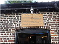
The Wheelhouse at Merton Abbey Mills
The waterwheel can be seen at https://www.geograph.org.uk/photo/6560964
Image: © Marathon
Taken: 1 Aug 2020
0.06 miles
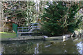
10
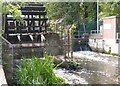
The waterwheel at Merton Abbey Mills
The waterwheel on the River Wandle at Merton Abbey Mills dates from about 1860 and is London's only working example. Liberty used it to drive spools to rinse the silk after gumming and printing. This view looks upriver. See also https://www.geograph.org.uk/photo/6560966
Image: © Marathon
Taken: 1 Aug 2020
0.06 miles