IMAGES TAKEN NEAR TO
Hogarth Crescent, LONDON, SW19 2DW
Introduction
This page details the photographs taken nearby to Hogarth Crescent, SW19 2DW by members of the Geograph project.
The Geograph project started in 2005 with the aim of publishing, organising and preserving representative images for every square kilometre of Great Britain, Ireland and the Isle of Man.

There are currently over 7.5m images from over14,400 individuals and you can help contribute to the project by visiting https://www.geograph.org.uk
Image Map
Images are licensed for reuse under creativecommons.org/licenses/by-sa/2.0
Notes
- Clicking on the map will re-center to the selected point.
- The higher the marker number, the further away the image location is from the centre of the postcode.
Image Listing (40 Images Found)
Images are licensed for reuse under creativecommons.org/licenses/by-sa/2.0
Image
Details
Distance
2
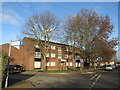
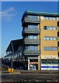
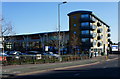
Flats near Mitcham
A low-rise block of flats near Mitcham, in the suburbs of south London.
This image was taken in early January. The trees were bare, the sun was low in the sky and the shadows were long.
Image: © Malc McDonald
Taken: 4 Jan 2020
0.12 miles
3
Christchurch Road looking towards Tandem Way shopping centre
Image: © David Howard
Taken: 1 Dec 2013
0.13 miles
4
Yarborough Road at the junction of Liberty Avenue
Image: © David Howard
Taken: 1 Dec 2013
0.13 miles
5
The Colour Shop, Merton Abbey Mills
Part of the William Morris print works
Image: © Noel Foster
Taken: 14 Jun 2005
0.15 miles
6
Industrial building on Church Road, Mitcham
This is divided up into several small units, just about all anonymous.
Image: © Robin Webster
Taken: 1 Apr 2012
0.16 miles
7
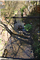
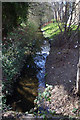
Pickle Ditch, Merton
This is the section of Pickle Ditch that runs parallel to Runnymede between Christchurch Road and its southern confluence with the River Wandle. Taken looking downstream from the bridge linking Runnymede and Merton Mills.
Image: © David Kemp
Taken: 26 Mar 2018
0.18 miles
8
Jessops, Christchurch Road, Merton
Located on the edge of the Tandem Centre.
Image: © Peter Trimming
Taken: 25 Feb 2012
0.18 miles
9
Pickle Ditch, Merton
This is the section of Pickle Ditch that runs parallel to Runnymede between Christchurch Road and its southern confluence with the River Wandle. Taken looking upstream from the bridge linking Runnymede and Merton Mills.
Image: © David Kemp
Taken: 26 Mar 2018
0.19 miles
10
Jessops, Christchurch Road, Merton
Located on the edge of the Tandem Centre.
Image: © Peter Trimming
Taken: 25 Feb 2012
0.19 miles