IMAGES TAKEN NEAR TO
High Street Colliers Wood, LONDON, SW19 2BT
Introduction
This page details the photographs taken nearby to High Street Colliers Wood, SW19 2BT by members of the Geograph project.
The Geograph project started in 2005 with the aim of publishing, organising and preserving representative images for every square kilometre of Great Britain, Ireland and the Isle of Man.

There are currently over 7.5m images from over14,400 individuals and you can help contribute to the project by visiting https://www.geograph.org.uk
Image Map (Loading...)


Getting Data...Please wait
Leaflet Map data © OpenStreetMap
Images are licensed for reuse under creativecommons.org/licenses/by-sa/2.0
Notes
- Clicking on the map will re-center to the selected point.
- The higher the marker number, the further away the image location is from the centre of the postcode.
Image Listing (109 Images Found)
Images are licensed for reuse under creativecommons.org/licenses/by-sa/2.0
Image
Details
Distance
1
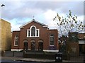
Saint Joseph's Catholic Church, Collier's Wood
On the A24 Collier's Wood High Street.
Image: © David Anstiss
Taken: 9 Dec 2012
0.02 miles
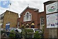
5
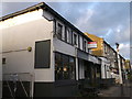
The Prince, Collier's Wood
Disused public house, on the A24 Collier's Wood High Street.
Image: © David Anstiss
Taken: 9 Dec 2012
0.05 miles
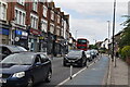
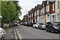
6
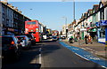
High Street, Collier's Wood
Looking in the direction of Tooting, whilst sneaking across the road with traffic stopped at a pedestrian crossing. Note the cycle route.
Image: © Peter Trimming
Taken: 25 Feb 2012
0.05 miles
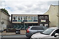
10
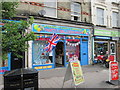
Upside down Union Flag #37
At Eternity Party Express, Collier's Wood.
Image: © Ian S
Taken: 2 Jun 2012
0.07 miles