IMAGES TAKEN NEAR TO
Wycliffe Road, LONDON, SW19 1ER
Introduction
This page details the photographs taken nearby to Wycliffe Road, SW19 1ER by members of the Geograph project.
The Geograph project started in 2005 with the aim of publishing, organising and preserving representative images for every square kilometre of Great Britain, Ireland and the Isle of Man.

There are currently over 7.5m images from over14,400 individuals and you can help contribute to the project by visiting https://www.geograph.org.uk
Image Map
Images are licensed for reuse under creativecommons.org/licenses/by-sa/2.0
Notes
- Clicking on the map will re-center to the selected point.
- The higher the marker number, the further away the image location is from the centre of the postcode.
Image Listing (46 Images Found)
Images are licensed for reuse under creativecommons.org/licenses/by-sa/2.0
Image
Details
Distance
1
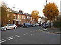
Wycliffe Road at the junction of Latimer Road
Image: © David Howard
Taken: 1 Dec 2013
0.01 miles
2
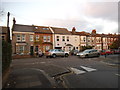
South Park Road at the junction of Wycliffe Road
Image: © David Howard
Taken: 1 Dec 2013
0.07 miles
3
Looking east on Quicks Road
The Old Church has been converted to office suites.
Image: © Shazz
Taken: 10 Jan 2014
0.08 miles
4
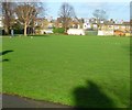
Recreation Ground on Quicks Road
The three dogs were having fun.
Image: © Shazz
Taken: 10 Jan 2014
0.09 miles
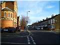
5
The rear eantrance to Wimbledon Leisure Centre
On South Park Road
Image: © David Howard
Taken: 1 Dec 2013
0.09 miles
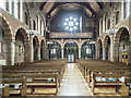
6
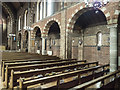
St Widefride, Latimer Road - South arcade
Image: © John Salmon
Taken: 9 Mar 2018
0.11 miles
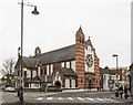
8
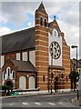
Wimbledon : Church of St Winefride (Roman Catholic)
Grade II listed church, architect : Frederick A. Walters.
Image: © Jim Osley
Taken: 2 Oct 2019
0.11 miles
10
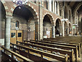
St Widefride, Latimer Road - North arcade
Image: © John Salmon
Taken: 9 Mar 2018
0.12 miles