IMAGES TAKEN NEAR TO
Wandle Bank, LONDON, SW19 1DW
Introduction
This page details the photographs taken nearby to Wandle Bank, SW19 1DW by members of the Geograph project.
The Geograph project started in 2005 with the aim of publishing, organising and preserving representative images for every square kilometre of Great Britain, Ireland and the Isle of Man.

There are currently over 7.5m images from over14,400 individuals and you can help contribute to the project by visiting https://www.geograph.org.uk
Image Map (Loading...)


Getting Data...Please wait
Leaflet Map data © OpenStreetMap
Images are licensed for reuse under creativecommons.org/licenses/by-sa/2.0
Notes
- Clicking on the map will re-center to the selected point.
- The higher the marker number, the further away the image location is from the centre of the postcode.
Image Listing (119 Images Found)
Images are licensed for reuse under creativecommons.org/licenses/by-sa/2.0
Image
Details
Distance
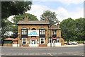
1
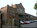
Merton bus garage - eastern elevation
This shows the Wandle Bank entrance to the garage. Given the number of cars usually parked outside it, this entrance is unlikely be in regular use.
Image: © David Kemp
Taken: 1 Nov 2017
0.01 miles
3
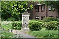
Drinking Fountain, Wandle Park
Grade II listed.
Image: © N Chadwick
Taken: 21 May 2023
0.07 miles
4
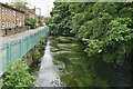
Merton bus garage
The entrance to London General's Merton bus garage, on Merton High Street. From the street, the bus garage looks small but it extends a long way back with extensions to the side (just visible) and the rear. In the foreground is the River Wandle.
Image: © Malc McDonald
Taken: 5 Jun 2010
0.07 miles
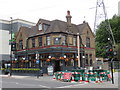
5
Istanbul Mese Mangal
A Mediterranean restaurant on Merton High Street in what looks like a former pub.
Image: © Des Blenkinsopp
Taken: 9 Jul 2018
0.07 miles
7

Memorial fountain in Wandle Park
The drinking fountain is now disused. The inscription on it records a dedication to Harry Ashby and Robert Fenwick and refers to their involvement in the formation of the new parish of All Saints, South Wimbledon Image
Image: © Stephen Craven
Taken: 29 Aug 2011
0.07 miles
8
Former pub, Merton High Street
The head office of Go-Ahead London bus company, formerly the King's Head pub.
Image: © Malc McDonald
Taken: 26 Jun 2010
0.08 miles
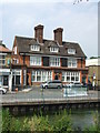
9
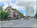
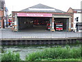
Former Royal Six Bells
Pub built the c.1850s after an earlier version had been demolished to make way for a water main. Originally the Five Bells, it later became the Six Bells, adding the Royal title after Edward, Prince of Wales (later Edward VII), used it as a stopover en route to the races at Epsom. It has since had various other names: Riverside (reflecting its position by the River Wandle), Baobab and Blue. It closed as a pub following flooding in 2007, reopening 4 years later as an Indian restaurant, Delhi Heights. It is now a Turkish restaurant, Istanbul Mezze Mangal.
In the background is Britannia Point. This was originally built in 1966 as an office block named Lyon House, but more generally known as Colliers Wood Tower, and was considered one of the ugliest buildings in London. A major renovation was carried out 2014-7 which saw its conversion to residential apartments.
Image: © Ian Capper
Taken: 7 Oct 2022
0.08 miles
10
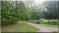
Footbridge in Wandle Park, Collier's Wood
Image: © Mike Pennington
Taken: 28 Jul 2015
0.08 miles