IMAGES TAKEN NEAR TO
Merton High Street, LONDON, SW19 1BA
Introduction
This page details the photographs taken nearby to Merton High Street, SW19 1BA by members of the Geograph project.
The Geograph project started in 2005 with the aim of publishing, organising and preserving representative images for every square kilometre of Great Britain, Ireland and the Isle of Man.

There are currently over 7.5m images from over14,400 individuals and you can help contribute to the project by visiting https://www.geograph.org.uk
Image Map (Loading...)


Getting Data...Please wait
Leaflet Map data © OpenStreetMap
Images are licensed for reuse under creativecommons.org/licenses/by-sa/2.0
Notes
- Clicking on the map will re-center to the selected point.
- The higher the marker number, the further away the image location is from the centre of the postcode.
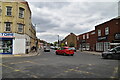
Image Listing (101 Images Found)
Images are licensed for reuse under creativecommons.org/licenses/by-sa/2.0
Image
Details
Distance
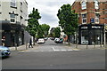
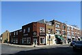
3
Merton High Street looking east from the junction with Victory Road
Image: © Shazz
Taken: 10 Jan 2014
0.03 miles
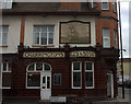
6
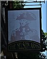
Sign for the Nelson Arms, Merton
See Image] for context.
Image: © JThomas
Taken: 29 Jul 2022
0.05 miles
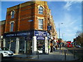
8
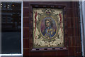
The Nelson, Merton High St.
A decorative detail on the outside of the pub. There is also a picture of HMS Victory.
Image: © Robert Eva
Taken: 16 Nov 2019
0.05 miles
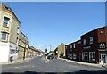
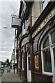
10
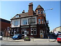
The Nelson Arms, Merton
On Merton High Street.
Image: © JThomas
Taken: 29 Jul 2022
0.06 miles