IMAGES TAKEN NEAR TO
Revelstoke Road, LONDON, SW18 5PD
Introduction
This page details the photographs taken nearby to Revelstoke Road, SW18 5PD by members of the Geograph project.
The Geograph project started in 2005 with the aim of publishing, organising and preserving representative images for every square kilometre of Great Britain, Ireland and the Isle of Man.

There are currently over 7.5m images from over14,400 individuals and you can help contribute to the project by visiting https://www.geograph.org.uk
Image Map
Images are licensed for reuse under creativecommons.org/licenses/by-sa/2.0
Notes
- Clicking on the map will re-center to the selected point.
- The higher the marker number, the further away the image location is from the centre of the postcode.
Image Listing (54 Images Found)
Images are licensed for reuse under creativecommons.org/licenses/by-sa/2.0
Image
Details
Distance
1
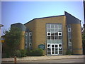
Southfields Methodist Church, Durnsford Road.
Corner of Ravensbury Road.
Image: © Noel Foster
Taken: 24 Jun 2005
0.04 miles
2
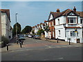
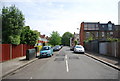
Trentham Street, Southfields
Trentham Street is a residential street in the suburbs of south London.
Image: © Malc McDonald
Taken: 1 Jul 2018
0.05 miles
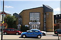
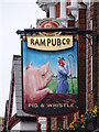
4
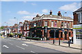
The Pig & Whistle
A Young's pub on the corner of Penwith Road and Merton Road.
Image: © Bill Boaden
Taken: 30 Jul 2011
0.08 miles
5
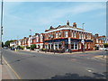
Pig & Whistle, near Southfields
The Pig & Whistle pub on Merton Road, Southfields.
Image: © Malc McDonald
Taken: 1 Jul 2018
0.08 miles
7
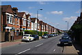
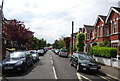
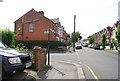
Terraced houses on Penwith Road
Another road where parking is an issue.
Image: © Bill Boaden
Taken: 30 Jul 2011
0.12 miles
9
Lucien Rd off Haslemere Avenue
Route of the Capital Ring.
Image: © N Chadwick
Taken: 7 May 2011
0.12 miles