IMAGES TAKEN NEAR TO
Merton Road, LONDON, SW18 5JN
Introduction
This page details the photographs taken nearby to Merton Road, SW18 5JN by members of the Geograph project.
The Geograph project started in 2005 with the aim of publishing, organising and preserving representative images for every square kilometre of Great Britain, Ireland and the Isle of Man.

There are currently over 7.5m images from over14,400 individuals and you can help contribute to the project by visiting https://www.geograph.org.uk
Image Map
Images are licensed for reuse under creativecommons.org/licenses/by-sa/2.0
Notes
- Clicking on the map will re-center to the selected point.
- The higher the marker number, the further away the image location is from the centre of the postcode.
Image Listing (54 Images Found)
Images are licensed for reuse under creativecommons.org/licenses/by-sa/2.0
Image
Details
Distance
1
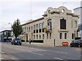
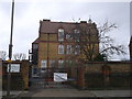
The former OK Sauce factory, Merton Road, Southfields
From the architectural point of view, a curious building - which I think you'd have to describe as Art Deco Classical. The classical elements are definitely there: the overall 'rustication' (the joints in the masonry are emphasised by recessing them); the proportions of the windows (some with keystones); the friezes at cornice level, and the pediments rising above roof level at each end. The most blatant Art Deco details are to be found high up - the rounded pediments with their circular openings, and the projecting friezes.
The factory was built in the late 1920's, and produced condiments until 1969. It has long since been converted for other uses - currently offices. I have to add that I've known the building for almost as long as I can remember, having spent my childhood in this part of London.
As for OK Sauce, it is many, many years since I last tasted the stuff - but imagine the result you'd get if you liquidised Branston Pickle (still available, I believe) and you'll get the general idea.
Image: © Stefan Czapski
Taken: 2 Oct 2012
0.01 miles
2
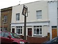
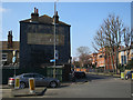
The Builders Arms, Longfield Street, Southfields
The pub has been converted to a private house but the pub sign remains.
Image: © Duncan Grey
Taken: 10 Jan 2010
0.02 miles
3
The Builders Arms, Longfield Street, Southfields
The pub has been converted to a private house but the pub sign remains.
Image: © Duncan Grey
Taken: 10 Jan 2010
0.04 miles
4

The Builders Arms, Longfield Street, Southfields
The pub has been converted to a private house but the pub sign remains.
The motto is "In God Is All We Trust And Let Us Never Be Confounded" which has its origins in the Psalms and is the motto of The Worshipful Company of Tylers and Bricklayers.
Image: © Duncan Grey
Taken: 10 Jan 2010
0.05 miles
5
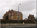
Riversdale School with Associated Caretaker's House, Southfields
Grade II listed school and caretaker's house (on the right).
On the junction of Pirbright Road and Replingham Road.
See http://www.britishlistedbuildings.co.uk/en-506995-riversdale-school-with-associated-careta for more details about the listed school.
Image: © David Anstiss
Taken: 30 Dec 2012
0.08 miles
6
Riversdale School, Southfields
Entrance to the Grade II listed school. On the junction of Pirbright Road and Replingham Road.
See http://www.britishlistedbuildings.co.uk/en-506995-riversdale-school-with-associated-careta for more details about the listed school.
Image: © David Anstiss
Taken: 30 Dec 2012
0.09 miles
7
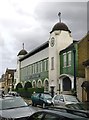
'Nourish & Flourish', Standen Road
Said once to have been a factory owned by Frame's Foods, manufacturers of baby foods. A quick web-search suggests that the site is now partly residential, partly offices. I spent my primary school days in Southfields, and the tops of the towers were a familiar sight, seen above the rooftops of the residential streets - but this narrow stretch of Standen Road is rather a backwater, and I have no clear memories of the green and white façade.
Image: © Stefan Czapski
Taken: 2 Oct 2012
0.12 miles
8
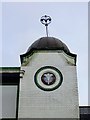
The 'Nourish & Flourish' building: detail (1)
Decorative tiling, glazed brickwork, and a wrought iron finial.
The building is said to date from the first decade of the 20th century, and was built as a baby-food factory. Present use seems to be mixed: offices and residential.
Image: © Stefan Czapski
Taken: 2 Oct 2012
0.12 miles
10
Southfield Community College
A newly constructed reception and rooms, for the college on the junction of Burr Road and Merton Road.
Image: © David Anstiss
Taken: 30 Dec 2012
0.14 miles