IMAGES TAKEN NEAR TO
Elborough Street, LONDON, SW18 5DW
Introduction
This page details the photographs taken nearby to Elborough Street, SW18 5DW by members of the Geograph project.
The Geograph project started in 2005 with the aim of publishing, organising and preserving representative images for every square kilometre of Great Britain, Ireland and the Isle of Man.

There are currently over 7.5m images from over14,400 individuals and you can help contribute to the project by visiting https://www.geograph.org.uk
Image Map
Images are licensed for reuse under creativecommons.org/licenses/by-sa/2.0
Notes
- Clicking on the map will re-center to the selected point.
- The higher the marker number, the further away the image location is from the centre of the postcode.
Image Listing (79 Images Found)
Images are licensed for reuse under creativecommons.org/licenses/by-sa/2.0
Image
Details
Distance
1
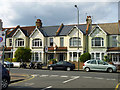
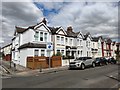
Houses on Replingham Road
These seem to date from approximately Edwardian times. Between 1896 and 1916 maps show a relatively bare tract of land from here south transformed into the present-day grid of residential streets.
Image: © Robin Webster
Taken: 14 Apr 2012
0.06 miles
2
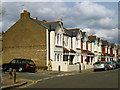
Houses on Lavenham Road
The nearest is on the corner of Elborough Street.
Image: © Robin Webster
Taken: 14 Apr 2012
0.15 miles
3
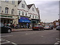
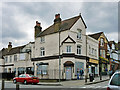
Tesco Express Southfields
Former pub (see Image) on the junction of Heythorp Street and Replingham Road. Has become a local supermarket for a large retail giant.
The Old Garage Pub is unchanged.
Image: © David Anstiss
Taken: 30 Dec 2012
0.15 miles
4
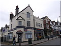
The Grid Inn - closed
The unusual situation of two pubs next door to each other. The Old Garage to the right survives, it seems to be a Greene King pub. The Grid Inn, a free house, fails.
Image: © Robin Webster
Taken: 14 Apr 2012
0.15 miles
6
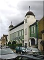
'Nourish & Flourish', Standen Road
Said once to have been a factory owned by Frame's Foods, manufacturers of baby foods. A quick web-search suggests that the site is now partly residential, partly offices. I spent my primary school days in Southfields, and the tops of the towers were a familiar sight, seen above the rooftops of the residential streets - but this narrow stretch of Standen Road is rather a backwater, and I have no clear memories of the green and white façade.
Image: © Stefan Czapski
Taken: 2 Oct 2012
0.15 miles
7
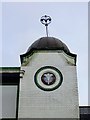
The 'Nourish & Flourish' building: detail (1)
Decorative tiling, glazed brickwork, and a wrought iron finial.
The building is said to date from the first decade of the 20th century, and was built as a baby-food factory. Present use seems to be mixed: offices and residential.
Image: © Stefan Czapski
Taken: 2 Oct 2012
0.15 miles
8
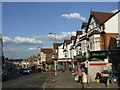
Replingham Road, Southfields
Local shops at Southfields. Parking cones indicate that the Wimbledon tennis tournament was taking place.
Image: © Malc McDonald
Taken: 3 Jul 2010
0.16 miles
9
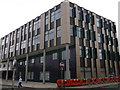
Southfield Community College
A newly constructed reception and rooms, for the college on the junction of Burr Road and Merton Road.
Image: © David Anstiss
Taken: 30 Dec 2012
0.16 miles