IMAGES TAKEN NEAR TO
Kimber Road, LONDON, SW18 4NX
Introduction
This page details the photographs taken nearby to Kimber Road, SW18 4NX by members of the Geograph project.
The Geograph project started in 2005 with the aim of publishing, organising and preserving representative images for every square kilometre of Great Britain, Ireland and the Isle of Man.

There are currently over 7.5m images from over14,400 individuals and you can help contribute to the project by visiting https://www.geograph.org.uk
Image Map
Images are licensed for reuse under creativecommons.org/licenses/by-sa/2.0
Notes
- Clicking on the map will re-center to the selected point.
- The higher the marker number, the further away the image location is from the centre of the postcode.
Image Listing (29 Images Found)
Images are licensed for reuse under creativecommons.org/licenses/by-sa/2.0
Image
Details
Distance
1
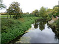
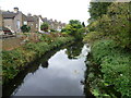
The River Wandle from Kimber Road
This is the River Wandle between Earlsfield and Wandsworth. King George's Park is on the left, whilst on the right are the back gardens of the houses in Twilley Street.
Image: © Marathon
Taken: 5 Oct 2011
0.02 miles
2
Bridge on Kimber Road, SW18
The bridge across the River Wandle, seen from the Wandle Trail as it crosses Kimber Road, roughly halfway between Earlsfield and Wandsworth.
Image: © Derek Harper
Taken: 30 Nov 2009
0.02 miles
3
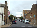
Twilley Street, near Wandsworth
Twilley Street, near Wandsworth in south west London.
Image: © Malc McDonald
Taken: 9 Jul 2016
0.02 miles
4
The River Wandle from Kimber Road
This is the River Wandle between Earlsfield and Wandsworth. King George's Park is on the right, whilst on the left are the back gardens of the houses in Twilley Street.
Image: © Marathon
Taken: 5 Oct 2011
0.06 miles
5
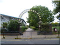
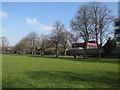
Entrance to King George's Park
King George's Park was originally called Southfields Park and was laid out in 1922. It was officially opened by King George V in 1938. The River Wandle forms the eastern boundary of the park, and the Wandle Trail passes through the park. The park is divided into three area of approximately equal size. This is the entrance to the middle part from Kimber Road.
Image: © Marathon
Taken: 5 Oct 2011
0.11 miles
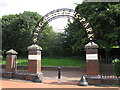
6
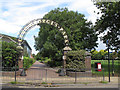
Entrance to King George's Park
The entrance from Kimber Road, along the Wandle Trail.
Image: © Stephen Craven
Taken: 29 Aug 2011
0.12 miles
7
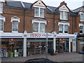
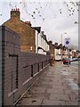
Tesco Express, Earlsfield
Small local supermarket on Garrett Lane.
With flats above.
Image: © David Anstiss
Taken: 30 Dec 2012
0.12 miles
8
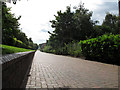
Follow the red brick road
This brick paved path through King George's Park is part of the Wandle Trail.
Image: © Stephen Craven
Taken: 29 Aug 2011
0.13 miles
9
Entrance to King George's Park
The entrance from Brathway Road at the western side of the park.
Image: © Stephen Craven
Taken: 29 Aug 2011
0.15 miles