IMAGES TAKEN NEAR TO
Steerforth Street, LONDON, SW18 4HF
Introduction
This page details the photographs taken nearby to Steerforth Street, SW18 4HF by members of the Geograph project.
The Geograph project started in 2005 with the aim of publishing, organising and preserving representative images for every square kilometre of Great Britain, Ireland and the Isle of Man.

There are currently over 7.5m images from over14,400 individuals and you can help contribute to the project by visiting https://www.geograph.org.uk
Image Map
Images are licensed for reuse under creativecommons.org/licenses/by-sa/2.0
Notes
- Clicking on the map will re-center to the selected point.
- The higher the marker number, the further away the image location is from the centre of the postcode.
Image Listing (81 Images Found)
Images are licensed for reuse under creativecommons.org/licenses/by-sa/2.0
Image
Details
Distance
1
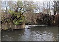
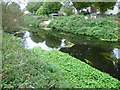
Weir on the Wandle
A small weir across the right-hand channel of the river near Earlsfield. Taken from the Wandle Trail, which crosses the river a few metres below the weir.
Image: © Derek Harper
Taken: 30 Nov 2009
0.04 miles
2
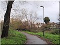
Wandle Trail, Earlsfield
The trail, followed by NCN22, approaches the river crossing at the weir at Trewint Street.
Image: © Derek Harper
Taken: 30 Nov 2009
0.04 miles
3
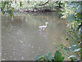
Heron in the Wandle
Herons eat fish and are supposedly a good indicator of water quality.
Image: © Stephen Craven
Taken: 29 Aug 2011
0.04 miles
4
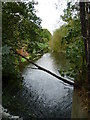
River Wandle from Trewint Street footbridge
The section of the Wandle Trail alongside the River Wandle between Trewint Street bridge and Plough Lane is largely surrounded by light industry as well as some allotments. Unfortunately, there is also a fair amount of dumped rubbish, especially in this northern section. This is the view from Trewint Street footbridge. The river briefly divides into two here - this is the weir on the easterly branch.
Image: © Marathon
Taken: 5 Oct 2011
0.05 miles
5
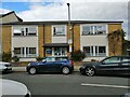
The Earlsfield Practice
One of Earlsfield's GP practices
Image: © Claudia Petersen
Taken: 15 Sep 2022
0.05 miles
6
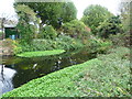
River Wandle near Earlsfield
The section of the Wandle Trail alongside the River Wandle between Trewint Street bridge and Plough Lane is largely surrounded by light industry as well as some allotments. Unfortunately, there is also a fair amount of dumped rubbish, especially in this northern section. This view looks across the river to the backs of the houses in Steerforth Street.
Image: © Marathon
Taken: 5 Oct 2011
0.05 miles
7
Weir on the Wandle, seen from the railway
Snatched from a moving train, this is the view one has of the River Wandle when travelling between Wimbledon and Earlsfield. The weir can be seen at closer quarters in Image
Image: © Christopher Hilton
Taken: 26 Jan 2015
0.06 miles
8
River Wandle near Earlsfield
The section of the Wandle Trail alongside the River Wandle between Trewint Street bridge and Plough Lane is largely surrounded by light industry as well as some allotments. Unfortunately, there is also a fair amount of dumped rubbish, especially in this northern section. This view looks across the river to the backs of the houses and their gardens in Steerforth Street.
Image: © Marathon
Taken: 5 Oct 2011
0.06 miles
9
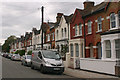
Trewint Street, SW18
Some of the houses in this street fetch in excess of £1m.
Image: © David Kemp
Taken: 7 Oct 2017
0.07 miles
10
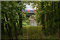
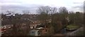
Railway bridge across River Wandle
This was taken from the footbridge at the end of Trewint Street. The train is on the SWR main line from Waterloo to Wimbledon and beyond. A picturesque spot in a not particularly picturesque area.
Image: © David Kemp
Taken: 7 Oct 2017
0.08 miles