IMAGES TAKEN NEAR TO
Burntwood Grange Road, LONDON, SW18 3JY
Introduction
This page details the photographs taken nearby to Burntwood Grange Road, SW18 3JY by members of the Geograph project.
The Geograph project started in 2005 with the aim of publishing, organising and preserving representative images for every square kilometre of Great Britain, Ireland and the Isle of Man.

There are currently over 7.5m images from over14,400 individuals and you can help contribute to the project by visiting https://www.geograph.org.uk
Image Map
Images are licensed for reuse under creativecommons.org/licenses/by-sa/2.0
Notes
- Clicking on the map will re-center to the selected point.
- The higher the marker number, the further away the image location is from the centre of the postcode.
Image Listing (18 Images Found)
Images are licensed for reuse under creativecommons.org/licenses/by-sa/2.0
Image
Details
Distance
1
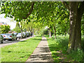
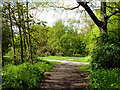
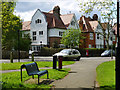
Path along west side of Wandsworth Common
Parallel with Sandgate Lane.
Image: © Robin Webster
Taken: 12 May 2012
0.11 miles
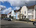
3
Burntwood Lane junction with Beechcroft Road
Image: © James Emmans
Taken: 13 May 2020
0.13 miles
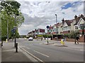
4
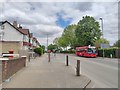
Bus on Burntwood Lane
The B229 road towards Wandsworth Common.
Image: © James Emmans
Taken: 13 May 2020
0.14 miles
6
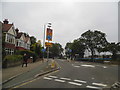
Mini roundabout on Burntwood Lane
At the junction of Beechcroft Road on the right
Image: © David Howard
Taken: 29 Sep 2013
0.14 miles
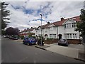
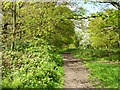
9
Lyford Road - Frewin road junction
Viewed from a path emerging from the wooded part of Wandsworth Common.
Image: © Robin Webster
Taken: 12 May 2012
0.15 miles