IMAGES TAKEN NEAR TO
Carmichael Mews, LONDON, SW18 3HH
Introduction
This page details the photographs taken nearby to Carmichael Mews, SW18 3HH by members of the Geograph project.
The Geograph project started in 2005 with the aim of publishing, organising and preserving representative images for every square kilometre of Great Britain, Ireland and the Isle of Man.

There are currently over 7.5m images from over14,400 individuals and you can help contribute to the project by visiting https://www.geograph.org.uk
Image Map
Images are licensed for reuse under creativecommons.org/licenses/by-sa/2.0
Notes
- Clicking on the map will re-center to the selected point.
- The higher the marker number, the further away the image location is from the centre of the postcode.
Image Listing (63 Images Found)
Images are licensed for reuse under creativecommons.org/licenses/by-sa/2.0
Image
Details
Distance
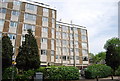
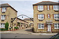
2
Carmichael Mews
Clearly a fairly new development. About 1950 this area was mapped as a joinery works.
Image: © Robin Webster
Taken: 12 May 2012
0.02 miles
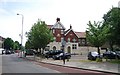
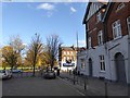
3
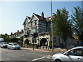
Wandsworth: The 'County Arms'
Large public house on the A219 (Trinity Road).
Image: © Dr Neil Clifton
Taken: 13 Jul 2013
0.03 miles
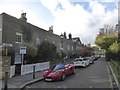
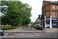
7
The County Arms, Trinity Road
The side of the pub, looking across Trinity Road to open space beyond
Image: © David Smith
Taken: 17 Nov 2016
0.04 miles
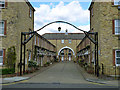
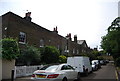
8
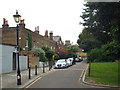
Alma Terrace, Wandsworth
Alma Terrace in Wandsworth, in south west London.
Image: © Malc McDonald
Taken: 9 Jul 2016
0.04 miles