IMAGES TAKEN NEAR TO
North Side Wandsworth Common, LONDON, SW18 2ST
Introduction
This page details the photographs taken nearby to North Side Wandsworth Common, SW18 2ST by members of the Geograph project.
The Geograph project started in 2005 with the aim of publishing, organising and preserving representative images for every square kilometre of Great Britain, Ireland and the Isle of Man.

There are currently over 7.5m images from over14,400 individuals and you can help contribute to the project by visiting https://www.geograph.org.uk
Image Map
Images are licensed for reuse under creativecommons.org/licenses/by-sa/2.0
Notes
- Clicking on the map will re-center to the selected point.
- The higher the marker number, the further away the image location is from the centre of the postcode.
Image Listing (91 Images Found)
Images are licensed for reuse under creativecommons.org/licenses/by-sa/2.0
Image
Details
Distance


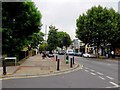
3

On Wandsworth Common
This was once the principal tract of waste land of the Manor of Battersea and Wandsworth and extended as far as Clapham to the east and Wimbledon to the west. One author suggests it has suffered from more encroachments than any other common in London. Between 1794 and 1866 there were 53 enclosures, including Wandsworth Prison and Emanuel School. Eventually a body of conservators succeeded in buying the land from Earl Spencer, the Lord of the Manor in 1871 by when the enclosures were looking like swallowing up the entire Common.
By 1887, when the Common was passed to the Metropolitan Board of Works, it condition was described as "disgraceful and neglected" and "bare, muddy and sloppy after a little rain, undrained and almost devoid of trees or seats". It was covered with gravel pits, many of which were full of stagnant water. Some of these now provide the lakes which are one of the principal features of Wandsworth Common.
At the north end of the Common are a number of small isolated areas of grass, divided up by railways, roads and housing. This is one of them between North Side Wandsworth Common, Trinity Road, Windmill Road and Spencer Park. In this view from next to North Side Wandsworth Common Spencer Park can be seen in the distance.
Image: © Marathon
Taken: 30 Mar 2016
0.09 miles
5

North Side Wandsworth Common
The road looks beguilingly quiet but it is actually the A3 during a temporary lull in the traffic.
Image: © Marathon
Taken: 30 Mar 2016
0.11 miles
6

St John's Hill SW11
At the junction of Spencer Road.
Image: © Danny P Robinson
Taken: 21 Aug 2006
0.11 miles
7

Illuminated sign board in Wandsworth
Olympic cycling gold-medallist Victoria Pendleton advertising a soft drink.
Image: © tristan forward
Taken: 17 Oct 2008
0.12 miles
8
St John's Therapy Centre
Opened for the local hospital trust in 2007 on St John's Hill
Image: © David Howard
Taken: 17 Aug 2009
0.12 miles