IMAGES TAKEN NEAR TO
Spencer Road, LONDON, SW18 2SP
Introduction
This page details the photographs taken nearby to Spencer Road, SW18 2SP by members of the Geograph project.
The Geograph project started in 2005 with the aim of publishing, organising and preserving representative images for every square kilometre of Great Britain, Ireland and the Isle of Man.

There are currently over 7.5m images from over14,400 individuals and you can help contribute to the project by visiting https://www.geograph.org.uk
Image Map
Images are licensed for reuse under creativecommons.org/licenses/by-sa/2.0
Notes
- Clicking on the map will re-center to the selected point.
- The higher the marker number, the further away the image location is from the centre of the postcode.
Image Listing (139 Images Found)
Images are licensed for reuse under creativecommons.org/licenses/by-sa/2.0
Image
Details
Distance
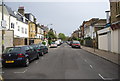
1

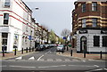
Spencer Road junction with Elsynge Road
Image: © James Emmans
Taken: 28 May 2022
0.01 miles
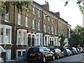
3
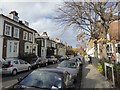
Vardens Road, SW11
Residential street close to Wandsworth Common
Image: © David Smith
Taken: 17 Nov 2016
0.06 miles
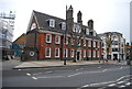
5

The Roundhouse, SW11
Gastro pub in Wandsworth
Image: © David Smith
Taken: 17 Nov 2016
0.06 miles
7

Building work on The Roundhouse
Business continues beneath.
Image: © Robin Webster
Taken: 6 May 2012
0.06 miles
8

The Roundhouse Public House, Wandsworth
Curved large Pub on the A3 Battersea Rise. near the junction with Vardens Road.
Image: © David Anstiss
Taken: 3 Jun 2012
0.07 miles
10
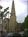
St. Peter and St. Paul church, St. John's Hill, Battersea.
Image: © Noel Foster
Taken: 8 Jul 2005
0.08 miles