IMAGES TAKEN NEAR TO
Acris Street, LONDON, SW18 2QR
Introduction
This page details the photographs taken nearby to Acris Street, SW18 2QR by members of the Geograph project.
The Geograph project started in 2005 with the aim of publishing, organising and preserving representative images for every square kilometre of Great Britain, Ireland and the Isle of Man.

There are currently over 7.5m images from over14,400 individuals and you can help contribute to the project by visiting https://www.geograph.org.uk
Image Map
Images are licensed for reuse under creativecommons.org/licenses/by-sa/2.0
Notes
- Clicking on the map will re-center to the selected point.
- The higher the marker number, the further away the image location is from the centre of the postcode.
Image Listing (57 Images Found)
Images are licensed for reuse under creativecommons.org/licenses/by-sa/2.0
Image
Details
Distance
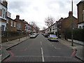
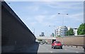
3

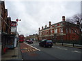
Trinity Road, Wandsworth
The A214 uses an underpass. While you cannot see the road, the route of the underpass is a huge concrete swathe through this area.
Image: © Bill Boaden
Taken: 3 Aug 2014
0.07 miles
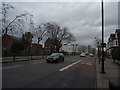
5

Flats on the corner of Huguenot Place and Trinity Road
Image: © David Howard
Taken: 25 Sep 2011
0.09 miles
6
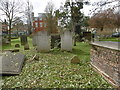
Huguenot Burial Ground, Wandsworth
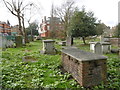
The Huguenot Burial Ground is located between two very busy roads - East Hill (A3036) and Huguenot Place A3). It was opened c.1687 as a burial ground for the French Church which stood opposite the Wandsworth parish church of All Saints. The burial ground was used by the Huguenot refugees who settled in Wandsworth during the 17th century, fleeing France after the Edict of Nantes in 1685. The burial ground later became known as Mount Nod; it was enlarged in 1700 and again in 1735. It was closed in 1854 and later reopened as a public garden. It is locked but easily viewed from the surrounding roads, and from the footpath to the east, from where this photograph is taken.
A much more detailed history with photographs can be seen at http://flickeringlamps.com/2014/09/12/mount-nod-the-almost-forgotten-resting-place-of-wandsworths-huguenots/
Image: © Marathon
Taken: 30 Mar 2016
0.09 miles
7
Huguenot Burial Ground, Wandsworth
The Huguenot Burial Ground is located between two very busy roads - East Hill (A3036) and Huguenot Place A3). It was opened c.1687 as a burial ground for the French Church which stood opposite the Wandsworth parish church of All Saints. The burial ground was used by the Huguenot refugees who settled in Wandsworth during the 17th century, fleeing France after the Edict of Nantes in 1685. The burial ground later became known as Mount Nod; it was enlarged in 1700 and again in 1735. It was closed in 1854 and later reopened as a public garden. It is locked but easily viewed from the surrounding roads, and from the footpath to the east, from where this photograph is taken.
A much more detailed history with photographs can be seen at http://flickeringlamps.com/2014/09/12/mount-nod-the-almost-forgotten-resting-place-of-wandsworths-huguenots/
Image: © Marathon
Taken: 30 Mar 2016
0.09 miles
8

Mosaic floor, entrance to "The County Arms", Wandsworth
Image: © Jim Osley
Taken: 25 Mar 2011
0.10 miles
10
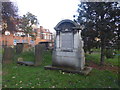
Huguenot Burial Ground from East Hill
The Huguenot Burial Ground is located between two very busy roads - East Hill (A3036) and Huguenot Place A3). It was opened c.1687 as a burial ground for the French Church which stood opposite the Wandsworth parish church of All Saints. The burial ground was used by the Huguenot refugees who settled in Wandsworth during the 17th century, fleeing France after the Edict of Nantes in 1685. The burial ground later became known as Mount Nod; it was enlarged in 1700 and again in 1735. It was closed in 1854 and later reopened as a public garden. It is locked but easily viewed from the surrounding roads, and from the footpath to the east. This photograph is taken from East Hill. At the time this photograph was taken, extensive restoration was taking place so that the burial ground could be opened up.
A much more detailed history with photographs can be seen at http://flickeringlamps.com/2014/09/12/mount-nod-the-almost-forgotten-resting-place-of-wandsworths-huguenots/ See also http://londongardensonline.org.uk/gardens-online-record.php?ID=WND022
Image: © Marathon
Taken: 29 Jan 2020
0.10 miles