IMAGES TAKEN NEAR TO
Rosehill Road, LONDON, SW18 2NY
Introduction
This page details the photographs taken nearby to Rosehill Road, SW18 2NY by members of the Geograph project.
The Geograph project started in 2005 with the aim of publishing, organising and preserving representative images for every square kilometre of Great Britain, Ireland and the Isle of Man.

There are currently over 7.5m images from over14,400 individuals and you can help contribute to the project by visiting https://www.geograph.org.uk
Image Map
Images are licensed for reuse under creativecommons.org/licenses/by-sa/2.0
Notes
- Clicking on the map will re-center to the selected point.
- The higher the marker number, the further away the image location is from the centre of the postcode.
Image Listing (107 Images Found)
Images are licensed for reuse under creativecommons.org/licenses/by-sa/2.0
Image
Details
Distance
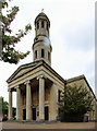
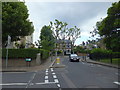
1
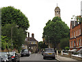
Rosehill Road, Wandsworth
Looking westwards towards St Anne's church.
Image: © Stephen Craven
Taken: 20 Jun 2014
0.02 miles
3
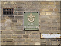
Scout headquarters
An old sign on the wall of St Anne's church hall Image
Image: © Stephen Craven
Taken: 20 Jun 2014
0.07 miles
4
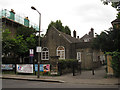
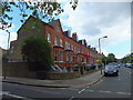
St Anne's church hall, Wandsworth
A modest brick building adjacent to the parish church of St Anne.
Image: © Stephen Craven
Taken: 20 Jun 2014
0.07 miles
6
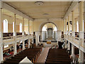
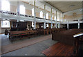
St Anne's church, Wandsworth: interior
A view from the west gallery showing the Georgian nave and Victorian apsidal sanctuary. See Image for the exterior.
Image: © Stephen Craven
Taken: 7 Apr 2014
0.08 miles
7
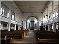
Interior of St Anne's Church, Wandsworth
St Anne's Church was completed on 29th July 1822 as one of the Commissioners' Waterloo churches. They were called Waterloo churches because they were looked upon as national monuments built in thanksgiving for the victory over Napoleon at Waterloo. St Anne's was the fifth Waterloo church.
It was designed by Robert Smirke who was also the architect of the British Museum. It was built on high ground above the Wandle Valley on the (then) edge of the suburbs.
A whole series of alterations were completed in the 1890s. A flying bomb in 1944 blew out almost all of the windows and left the tower and nave unsafe. In 1950, a fire again devastated the church and completely destroyed the roof. During the 1990s a second substantial programme of work was carried out leaving the church as it is seen here.
This view looks towards the chancel from the west end of the nave. The website for the church can be seen at http://stanneswandsworth.org.uk/
Image: © Marathon
Taken: 24 Feb 2021
0.08 miles

9
Junction of Aspley Road and St Anns Crescent, Wandswoth
Image: © PAUL FARMER
Taken: 17 Jun 2012
0.08 miles