IMAGES TAKEN NEAR TO
Parsons Mews, LONDON, SW18 2HE
Introduction
This page details the photographs taken nearby to Parsons Mews, SW18 2HE by members of the Geograph project.
The Geograph project started in 2005 with the aim of publishing, organising and preserving representative images for every square kilometre of Great Britain, Ireland and the Isle of Man.

There are currently over 7.5m images from over14,400 individuals and you can help contribute to the project by visiting https://www.geograph.org.uk
Image Map
Images are licensed for reuse under creativecommons.org/licenses/by-sa/2.0
Notes
- Clicking on the map will re-center to the selected point.
- The higher the marker number, the further away the image location is from the centre of the postcode.
Image Listing (174 Images Found)
Images are licensed for reuse under creativecommons.org/licenses/by-sa/2.0
Image
Details
Distance
1
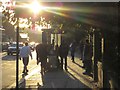
Bus stop, East Hill, Wandsworth
Into the evening sun beside the A3.
Image: © Derek Harper
Taken: 12 Oct 2012
0.02 miles
2

Huguenot Place, Wandsworth
On the right, beyond the Huguenot Burial Ground, is Book House (1888), home of the Publishing Training Centre, and formerly the Board of Works offices. Down East Hill is Image
Image: © Derek Harper
Taken: 25 Oct 2008
0.03 miles
3

Book House, Wandsworth
The facade carries the date 1888. It was built to accommodate the Wandsworth District Board of Works, and now houses the Publishing Training Centre. Behind it is the Huguenot Burial Ground.
Image: © Derek Harper
Taken: 12 Oct 2012
0.03 miles
4
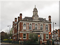
The Book House, Wandsworth
A prominent building on East Hill. Surprisingly, not listed. Another contributor gives its history at Image
Image: © Stephen Craven
Taken: 7 Apr 2014
0.04 miles
5
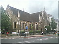
United Reformed Church, East Hill
East Hill United Reformed Church was formerly a Congregational church. It was designed by John G. Stapleton and begun in 1859. The earliest part of the church now forms the broad north-facing transept, seen on the right here. The nave of four bays with lower, lean-to side aisles was built from 1876.
Image: © Marathon
Taken: 14 Jul 2010
0.05 miles
6
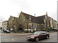
Wandsworth United Reformed Church
Built 1859-1876 and listed grade 2 (list entry number 1226105). See also Image
Image: © Stephen Craven
Taken: 7 Apr 2014
0.05 miles
7
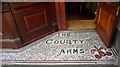
Mosaic floor, entrance to "The County Arms", Wandsworth
Image: © Jim Osley
Taken: 25 Mar 2011
0.06 miles
8
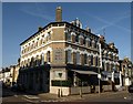
The East Hill, Wandsworth
A daylight view of the pub shown rather less clearly in Image
Image: © Derek Harper
Taken: 16 Oct 2011
0.06 miles
9
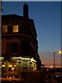
The East Hill, Wandsworth
Sunset seen past the pub at the junction of Alma Road and Fullerton Road.
Image: © Derek Harper
Taken: 11 Jun 2010
0.06 miles
10
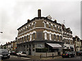
The East Hill pub, Wandsworth
The pub is on the corner of Fullerton Road and Alma Road. East Hill is the name of the nearby main road.
Image: © Stephen Craven
Taken: 7 Apr 2014
0.06 miles