IMAGES TAKEN NEAR TO
Daniel Close, LONDON, SW17 9DD
Introduction
This page details the photographs taken nearby to Daniel Close, SW17 9DD by members of the Geograph project.
The Geograph project started in 2005 with the aim of publishing, organising and preserving representative images for every square kilometre of Great Britain, Ireland and the Isle of Man.

There are currently over 7.5m images from over14,400 individuals and you can help contribute to the project by visiting https://www.geograph.org.uk
Image Map
Images are licensed for reuse under creativecommons.org/licenses/by-sa/2.0
Notes
- Clicking on the map will re-center to the selected point.
- The higher the marker number, the further away the image location is from the centre of the postcode.
Image Listing (58 Images Found)
Images are licensed for reuse under creativecommons.org/licenses/by-sa/2.0
Image
Details
Distance
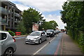
1
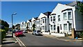
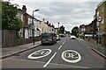
Colliers Wood - Robinson Road
Residential road that follows the railway line.
Image: © James Emmans
Taken: 8 May 2022
0.04 miles
2
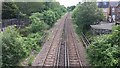
Railway east of High Street Colliers Wood
Image: © David Martin
Taken: 18 May 2017
0.05 miles
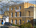
3
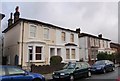
Villas on Robinson Road, Collier's Wood
Each pair of these semi-detached villas - there are three pairs here, one of which is on the left - has a name. The one in the centre is Lorne Villas, and it was inhabited at the 1881 census, by Joseph Tyler, a jeweller.
Image: © Derek Harper
Taken: 30 Nov 2009
0.05 miles
5
Waterfall House, Tooting High Street
Good three-bay three-storey house with single-bay wings and windows set in arched recesses. Dated c1800. Grade II listed.
It was named after a waterfall on the River Graveney in the house's grounds.
Home to the eponymous dental surgery.
Image: © Stephen Richards
Taken: 22 Mar 2015
0.10 miles
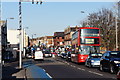
7
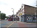
Tooting High Street, southern end
Yes, it's still Tooting High Street as far as the railway bridge. The bus, on the long route 57, Sutton to Clapham Park, is operated by RATP, whose major concern is the Paris Metro!
Image: © Dr Neil Clifton
Taken: 4 Jul 2013
0.11 miles
8
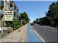
CS7 cycleway beside High Street, Collier's Wood
Image: © JThomas
Taken: 29 Jul 2022
0.11 miles
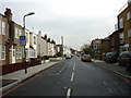
10
High Street, Collier's Wood
Looking in the direction of Tooting.
Image: © Peter Trimming
Taken: 25 Feb 2012
0.11 miles