IMAGES TAKEN NEAR TO
Chillerton Road, LONDON, SW17 9BE
Introduction
This page details the photographs taken nearby to Chillerton Road, SW17 9BE by members of the Geograph project.
The Geograph project started in 2005 with the aim of publishing, organising and preserving representative images for every square kilometre of Great Britain, Ireland and the Isle of Man.

There are currently over 7.5m images from over14,400 individuals and you can help contribute to the project by visiting https://www.geograph.org.uk
Image Map
Images are licensed for reuse under creativecommons.org/licenses/by-sa/2.0
Notes
- Clicking on the map will re-center to the selected point.
- The higher the marker number, the further away the image location is from the centre of the postcode.
Image Listing (32 Images Found)
Images are licensed for reuse under creativecommons.org/licenses/by-sa/2.0
Image
Details
Distance
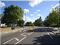
1
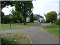
Furzedown Recreation Ground
Furzedown Recreation Ground was opened in 1924, the name recalling the former heathland here (furze being another name for gorse). This view looks across the recreation ground towards the entrance from Chillerton Road.
Image: © Marathon
Taken: 17 Sep 2014
0.01 miles
2
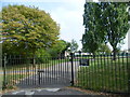
The entrance to Furzedown Recreation Ground from Chillerton Road
Furzedown Recreation Ground was opened in 1924, the name recalling the former heathland here (furze being another name for gorse). This view looks across the recreation ground from the entrance in Chillerton Road.
Image: © Marathon
Taken: 17 Sep 2014
0.02 miles
3
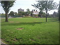
Furzedown Recreation Ground
Furzedown Recreation Ground was opened in 1924, the name recalling the former heathland here (furze being another name for gorse). This view looks across the recreation ground from the entrance in Chillerton Road. The building on the far side with the sloping roof belongs to Graveney School and the tall block is part of Furzedown Halls of Residence.
Image: © Marathon
Taken: 1 Sep 2010
0.06 miles
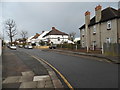
6
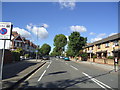
Crowborough Road at the junction of Ramsdale Road
Image: © David Howard
Taken: 22 Mar 2014
0.09 miles
7
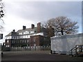
Graveney School, Furzedown
Graveney School is a secondary school with specialist Technology College status.
The school has various buildings on the large campus on Spalding Road.
Image: © David Anstiss
Taken: 9 Dec 2012
0.09 miles
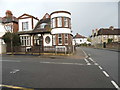
10
Crowborough Road at the junction of Ramsdale Road
Image: © David Howard
Taken: 22 Mar 2014
0.11 miles