IMAGES TAKEN NEAR TO
Netherfield Road, LONDON, SW17 8AZ
Introduction
This page details the photographs taken nearby to Netherfield Road, SW17 8AZ by members of the Geograph project.
The Geograph project started in 2005 with the aim of publishing, organising and preserving representative images for every square kilometre of Great Britain, Ireland and the Isle of Man.

There are currently over 7.5m images from over14,400 individuals and you can help contribute to the project by visiting https://www.geograph.org.uk
Image Map
Images are licensed for reuse under creativecommons.org/licenses/by-sa/2.0
Notes
- Clicking on the map will re-center to the selected point.
- The higher the marker number, the further away the image location is from the centre of the postcode.
Image Listing (136 Images Found)
Images are licensed for reuse under creativecommons.org/licenses/by-sa/2.0
Image
Details
Distance
1
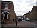
Netherfield Road, Tooting Bec
From Tooting Bec Road
Image: © David Howard
Taken: 5 Apr 2015
0.01 miles

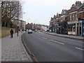
3
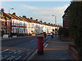
Tooting Bec Road
Tooting Bec Road runs from Tooting Bec Underground station to Streatham across Tooting Common. It is seen here at its junction with Netherfield Road.
Image: © Stephen McKay
Taken: 14 Dec 2017
0.03 miles

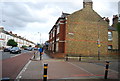


10
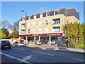
Upper Tooting, Sainsbury's Local
On Tooting Bec Road.
Image: © Mike Faherty
Taken: 23 Nov 2013
0.06 miles