IMAGES TAKEN NEAR TO
St. Hughes Close, LONDON, SW17 7UE
Introduction
This page details the photographs taken nearby to St. Hughes Close, SW17 7UE by members of the Geograph project.
The Geograph project started in 2005 with the aim of publishing, organising and preserving representative images for every square kilometre of Great Britain, Ireland and the Isle of Man.

There are currently over 7.5m images from over14,400 individuals and you can help contribute to the project by visiting https://www.geograph.org.uk
Image Map
Images are licensed for reuse under creativecommons.org/licenses/by-sa/2.0
Notes
- Clicking on the map will re-center to the selected point.
- The higher the marker number, the further away the image location is from the centre of the postcode.
Image Listing (22 Images Found)
Images are licensed for reuse under creativecommons.org/licenses/by-sa/2.0
Image
Details
Distance
1
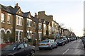
Wandle Road, SW17
Houses on the northern side of the western end of the road.
Image: © Derek Harper
Taken: 3 Feb 2011
0.03 miles
2
College Gardens, Upper Tooting
College gardens is a residential street in Upper Tooting, in the suburbs of sotuh London.
Image: © Malc McDonald
Taken: 1 Jul 2018
0.04 miles
3
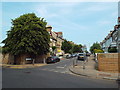
Brodrick Road, Upper Tooting
Brodrick Road is a residential street in Upper Tooting, in the suburbs of south London.
Image: © Malc McDonald
Taken: 1 Jul 2018
0.07 miles
4
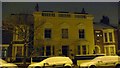
The Old Farm, Wandle Road
The Old Farm house, Wandle Road, in the early morning, after snow
Image: © Herry Lawford
Taken: 24 Jan 2007
0.08 miles
5
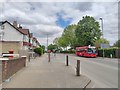
Bus on Burntwood Lane
The B229 road towards Wandsworth Common.
Image: © James Emmans
Taken: 13 May 2020
0.16 miles
6
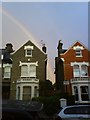
44 and 42 Hendham Road, Wandsworth Common, and rainbow
This enormous double rainbow with parallel shadow appeared in the evening of 9 August 2008.
Image: © Moonrocker
Taken: 9 Aug 2008
0.17 miles
7
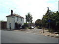
Mini roundabout on Burntwood Lane
At the junction of Beechcroft Road on the right
Image: © David Howard
Taken: 29 Sep 2013
0.17 miles
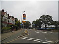
8

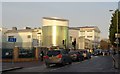
Ernest Bevin School, Beechcroft Road, Tooting.
Image: © Noel Foster
Taken: 20 Jun 2005
0.17 miles
9
Burntwood Lane junction with Beechcroft Road
Image: © James Emmans
Taken: 13 May 2020
0.17 miles
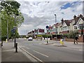
10
Ernest Bevin School
Traffic queues at a pedestrian crossing on Beechcroft Road by the school, which was renamed Ernest Bevin College in June 1997. It has specialisms in sports, maths and computing. Prominent here is the Sports and Sixth Form Centre, opened in September 2007 by Dame Kelly Holmes. See also Image
Image: © Derek Harper
Taken: 3 Feb 2011
0.19 miles