IMAGES TAKEN NEAR TO
SW17 7QZ
Introduction
This page details the photographs taken nearby to SW17 7QZ by members of the Geograph project.
The Geograph project started in 2005 with the aim of publishing, organising and preserving representative images for every square kilometre of Great Britain, Ireland and the Isle of Man.

There are currently over 7.5m images from over14,400 individuals and you can help contribute to the project by visiting https://www.geograph.org.uk
Image Map
Images are licensed for reuse under creativecommons.org/licenses/by-sa/2.0
Notes
- Clicking on the map will re-center to the selected point.
- The higher the marker number, the further away the image location is from the centre of the postcode.
Image Listing (120 Images Found)
Images are licensed for reuse under creativecommons.org/licenses/by-sa/2.0
Image
Details
Distance
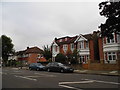
1
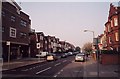
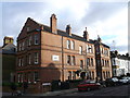
Wontner Road
A street of decorated terraced houses, seen from the junction with Upper Tooting Park.
Image: © Derek Harper
Taken: 13 Jan 2011
0.04 miles
3
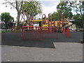
Children's Playground
Children's Playground on Upper Tooting Park
Image: © Shaun Ferguson
Taken: 10 Jul 2009
0.09 miles
5
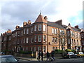
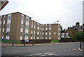
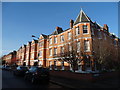
Boundaries Mansions, Balham
Large red-brick block of housing on Boundaries Road beside Tunley Road (on the right).
Image: © David Anstiss
Taken: 9 Dec 2012
0.11 miles
6
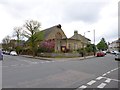
Balham, St. Jude's
Free Church of England church, at the corner of Heslop and Sarsfeld Roads: http://www.fcofesd.org.uk/history.html
Image: © Mike Faherty
Taken: 27 Apr 2013
0.14 miles
7
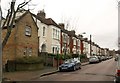
Rowfant Mansions, Balham
Large red-brick block of housing on Rowfant Road beside Boundaries Road (on the left).
Image: © David Anstiss
Taken: 9 Dec 2012
0.14 miles
8
Marius Road at the junction of Balham High Road
Image: © David Howard
Taken: 29 Sep 2013
0.15 miles