IMAGES TAKEN NEAR TO
Noyna Road, LONDON, SW17 7PH
Introduction
This page details the photographs taken nearby to Noyna Road, SW17 7PH by members of the Geograph project.
The Geograph project started in 2005 with the aim of publishing, organising and preserving representative images for every square kilometre of Great Britain, Ireland and the Isle of Man.

There are currently over 7.5m images from over14,400 individuals and you can help contribute to the project by visiting https://www.geograph.org.uk
Image Map
Images are licensed for reuse under creativecommons.org/licenses/by-sa/2.0
Notes
- Clicking on the map will re-center to the selected point.
- The higher the marker number, the further away the image location is from the centre of the postcode.
Image Listing (183 Images Found)
Images are licensed for reuse under creativecommons.org/licenses/by-sa/2.0
Image
Details
Distance
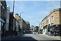
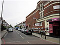
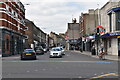
3
Holderness Road, junction with Trinity Road
Image: © Stacey Harris
Taken: 12 Sep 2001
0.05 miles
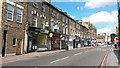
5
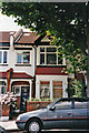
Mandrake Road, London SW17
At one time one of my ancestors lived here
Image: © Christine Matthews
Taken: 15 Jul 1999
0.06 miles
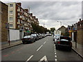
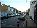
10
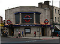
Tooting Bec Underground Station
Once known as Trinity Road.
Image: © Jim Osley
Taken: 14 Jun 2012
0.07 miles