IMAGES TAKEN NEAR TO
Lingwell Road, LONDON, SW17 7NJ
Introduction
This page details the photographs taken nearby to Lingwell Road, SW17 7NJ by members of the Geograph project.
The Geograph project started in 2005 with the aim of publishing, organising and preserving representative images for every square kilometre of Great Britain, Ireland and the Isle of Man.

There are currently over 7.5m images from over14,400 individuals and you can help contribute to the project by visiting https://www.geograph.org.uk
Image Map
Images are licensed for reuse under creativecommons.org/licenses/by-sa/2.0
Notes
- Clicking on the map will re-center to the selected point.
- The higher the marker number, the further away the image location is from the centre of the postcode.
Image Listing (18 Images Found)
Images are licensed for reuse under creativecommons.org/licenses/by-sa/2.0
Image
Details
Distance
1

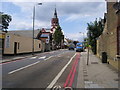
Ernest Bevin School
Traffic queues at a pedestrian crossing on Beechcroft Road by the school, which was renamed Ernest Bevin College in June 1997. It has specialisms in sports, maths and computing. Prominent here is the Sports and Sixth Form Centre, opened in September 2007 by Dame Kelly Holmes. See also Image
Image: © Derek Harper
Taken: 3 Feb 2011
0.18 miles
2
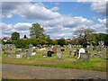
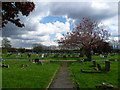
Streatham Cemetery
The lodge has an inscription dated 1892, but that was possibly the start of work, for the cemetery opened for burials in 1894.
Image: © Robin Webster
Taken: 12 May 2012
0.18 miles
3
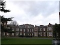
Block 14 of Springfield University Hospital
Springfield University Hospital is a psychiatric hospital in Tooting, South London and also the headquarters of the South West London and St George's Mental Health NHS Trust.
Block 14 is a wing on the right of the main building.
Image: © David Anstiss
Taken: 9 Dec 2012
0.19 miles
5

Ernest Bevin School, Beechcroft Road, Tooting.
Image: © Noel Foster
Taken: 20 Jun 2005
0.21 miles
6
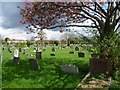
Streatham Cemetery
Under the Metropolitan Burial Act of 1852, which was in response to the second cholera epidemic of 1848-49, the Streatham Burial Board acquired the land in what was then countryside. With two lodges and two mirror image chapels built in the Gothic style by William Newton-Dunn, Streatham Cemetery opened for burials in 1894. Although Streatham Cemetery is owned by the Borough of Lambeth, it is actually in Tooting in the Borough of Wandsworth. The houses beyond are in Hebdon Road.
Image: © Marathon
Taken: 11 Apr 2012
0.22 miles
7
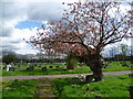
Path in Streatham Cemetery
Under the Metropolitan Burial Act of 1852, which was in response to the second cholera epidemic of 1848-49, the Streatham Burial Board acquired the land in what was then countryside. With two lodges and two mirror image chapels built in the Gothic style by William Newton-Dunn, Streatham Cemetery opened for burials in 1894. Although Streatham Cemetery is owned by the Borough of Lambeth, it is actually in Tooting in the Borough of Wandsworth.
Image: © Marathon
Taken: 11 Apr 2012
0.22 miles
8
Meeting of paths in Streatham Cemetery
Under the Metropolitan Burial Act of 1852, which was in response to the second cholera epidemic of 1848-49, the Streatham Burial Board acquired the land in what was then countryside. With two lodges and two mirror image chapels built in the Gothic style by William Newton-Dunn, Streatham Cemetery opened for burials in 1894. Although Streatham Cemetery is owned by the Borough of Lambeth, it is actually in Tooting in the Borough of Wandsworth. The houses in the distance are in Fishponds Road.
Image: © Marathon
Taken: 11 Apr 2012
0.22 miles
9
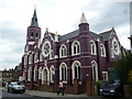
Tooting: New Testament Assembly Church
Whoever they are.
Image: © Dr Neil Clifton
Taken: 10 Jul 2013
0.22 miles
10
St Peter's Church
St Peter's Church Beechcroft Road
Image: © Shaun Ferguson
Taken: 10 Jul 2009
0.23 miles