IMAGES TAKEN NEAR TO
Brenda Road, LONDON, SW17 7DD
Introduction
This page details the photographs taken nearby to Brenda Road, SW17 7DD by members of the Geograph project.
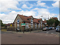
The Geograph project started in 2005 with the aim of publishing, organising and preserving representative images for every square kilometre of Great Britain, Ireland and the Isle of Man.

There are currently over 7.5m images from over14,400 individuals and you can help contribute to the project by visiting https://www.geograph.org.uk
Image Map
Images are licensed for reuse under creativecommons.org/licenses/by-sa/2.0
Notes
- Clicking on the map will re-center to the selected point.
- The higher the marker number, the further away the image location is from the centre of the postcode.
Image Listing (65 Images Found)
Images are licensed for reuse under creativecommons.org/licenses/by-sa/2.0
Image
Details
Distance
1

Ernest Bevin School, Beechcroft Road, Tooting.
Image: © Noel Foster
Taken: 20 Jun 2005
0.09 miles
3
Fircroft Primary School, Tooting
The school is on the corner of Fircroft Road and Glenburnie Road
Image: © Stephen Craven
Taken: 26 Aug 2008
0.09 miles
4
Fire station, Trinity Road, Upper Tooting
Grade 2 listed (list entry number 1266001) for being "among the best examples of a remarkable group of fire stations built by the LCC between 1896-1914, each executed to a bespoke design". This one dates from 1907.
Image: © Stephen Craven
Taken: 10 Jun 2015
0.10 miles
5
Tooting Fire Station
Large Grade II listed building on Trinity Road.
See http://www.britishlistedbuildings.co.uk/en-423294-tooting-fire-station-greater-london-auth for more details on the building.
Image: © David Anstiss
Taken: 9 Dec 2012
0.10 miles
6

Ernest Bevin School
Traffic queues at a pedestrian crossing on Beechcroft Road by the school, which was renamed Ernest Bevin College in June 1997. It has specialisms in sports, maths and computing. Prominent here is the Sports and Sixth Form Centre, opened in September 2007 by Dame Kelly Holmes. See also Image
Image: © Derek Harper
Taken: 3 Feb 2011
0.10 miles
7
Fircroft School, Tooting
Since I last photographed it in 2008 Image, this school building has not changed much apart from replacement of the end windows.
Image: © Stephen Craven
Taken: 10 Jun 2015
0.11 miles
8
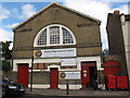
Tooting Neighbourhood Centre
Since I last photographed it in 2008 Image, this former mission church dating from 1896 has added the banner of the Institute of Theology and Christian Counselling.
Image: © Stephen Craven
Taken: 10 Jun 2015
0.12 miles
9
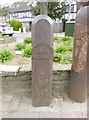
Old Boundary Marker by the A214, Trinity Road, Wandsworth
Parish Boundary Marker by the A214, in parish of Wandsworth (Wandsworth District), Trinity Road SW17, at junction with St James's Drive against flower bed wall. Adjacent to SY_BATT25pb Image
Inscription reads:-
WANDSWORTH
1884
PARISH
Surveyed
Milestone Society National ID: SY_WAND01pb
Image: © Milestone Society
Taken: Unknown
0.12 miles
10
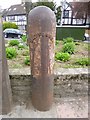
Old Boundary Marker by the A214, Trinity Road, Battersea parish
Parish Boundary Marker by the A214, in parish of Battersea (Wandsworth District), Trinity Road SW17, at junction with St James's Drive against flower bed wall. Adjacent to SY_WAND01pb Image
Inscription reads:-
BATTERSEA
Surveyed
Milestone Society National ID: SY_BATT25pb
Image: © Milestone Society
Taken: Unknown
0.12 miles