IMAGES TAKEN NEAR TO
Balham High Road, LONDON, SW17 7AA
Introduction
This page details the photographs taken nearby to Balham High Road, SW17 7AA by members of the Geograph project.
The Geograph project started in 2005 with the aim of publishing, organising and preserving representative images for every square kilometre of Great Britain, Ireland and the Isle of Man.

There are currently over 7.5m images from over14,400 individuals and you can help contribute to the project by visiting https://www.geograph.org.uk
Image Map
Images are licensed for reuse under creativecommons.org/licenses/by-sa/2.0
Notes
- Clicking on the map will re-center to the selected point.
- The higher the marker number, the further away the image location is from the centre of the postcode.
Image Listing (189 Images Found)
Images are licensed for reuse under creativecommons.org/licenses/by-sa/2.0
Image
Details
Distance
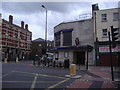
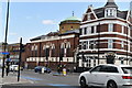
2
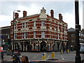
The Wheatsheaf, 2 Upper Tooting Road, London
Image: © Oxyman
Taken: 13 Aug 2007
0.02 miles
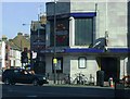
6
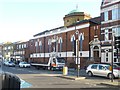
Upper Tooting, St Anselms RC Church
Main entrance on Balham High Road: http://www.stanselmstbec.plus.com/about.htm
Image: © Mike Faherty
Taken: 23 Nov 2013
0.02 miles
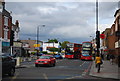
7
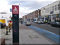
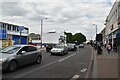
Cycle Super-highway CS7 Tooting Bec
Beside the A24 Balham High Road.
Image: © David Anstiss
Taken: 9 Dec 2012
0.03 miles
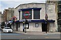
9
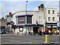
Tooting Bec Tube
Tooting Bec Tube station on the Northern Line, all the stations between South Clapham and Morden are built in this 30s style of architecture
Image: © Oxyman
Taken: 24 Apr 2007
0.03 miles