IMAGES TAKEN NEAR TO
Massingberd Way, LONDON, SW17 6AG
Introduction
This page details the photographs taken nearby to Massingberd Way, SW17 6AG by members of the Geograph project.
The Geograph project started in 2005 with the aim of publishing, organising and preserving representative images for every square kilometre of Great Britain, Ireland and the Isle of Man.

There are currently over 7.5m images from over14,400 individuals and you can help contribute to the project by visiting https://www.geograph.org.uk
Image Map (Loading...)


Getting Data...Please wait
Leaflet Map data © OpenStreetMap
Images are licensed for reuse under creativecommons.org/licenses/by-sa/2.0
Notes
- Clicking on the map will re-center to the selected point.
- The higher the marker number, the further away the image location is from the centre of the postcode.
Image Listing (60 Images Found)
Images are licensed for reuse under creativecommons.org/licenses/by-sa/2.0
Image
Details
Distance
1

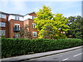
Elderfield Place
Modern blocks of flats, on a housing estate, beside Tooting Graveney Common.
Image: © Colin Smith
Taken: 19 Oct 2008
0.06 miles
2
New housing estate next to Church Lane
This new housing estate is seen across Church Lane. It is bounded by Mantilla Road, Franciscan Road and Tooting Bec Road as well as Church Lane.
Image: © Marathon
Taken: 17 Sep 2014
0.07 miles
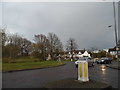
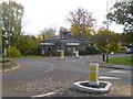
3

Old Boundary Marker by Church Lane, Tooting parish
Estate Boundary Marker by the B241, in parish of Tooting (Wandsworth District), Church Lane/Rectory Lane junction with Mantilla Road, against fence, by roundabout junction.
Inscription reads:-
LONDON
COUNTY
COUNCIL
BOUNDARY
Surveyed
Milestone Society National ID: SY_LCC22em
Image: © Milestone Society
Taken: Unknown
0.08 miles
6

Lisle Close
Cul-de-sac of apartment blocks on a modern housing estate by Tooting Graveney Common.
Image: © Colin Smith
Taken: 19 Oct 2008
0.13 miles
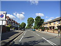
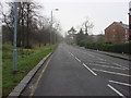
9

Massingberd Way
Autumn foliage by the spine road cutting through this housing estate by Tooting Graveney Common.
Image: © Colin Smith
Taken: 19 Oct 2008
0.15 miles
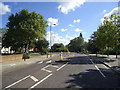
10
Furzedown Lodge
At the corner of Furzedown Road and Furzedown Drive; former lodge to Furzedown House. Mid-Victorian, listed by English Heritage: https://historicengland.org.uk/listing/the-list/list-entry/1065529
Image: © Mike Faherty
Taken: 23 Nov 2013
0.15 miles