IMAGES TAKEN NEAR TO
Deeside Road, LONDON, SW17 0PJ
Introduction
This page details the photographs taken nearby to Deeside Road, SW17 0PJ by members of the Geograph project.
The Geograph project started in 2005 with the aim of publishing, organising and preserving representative images for every square kilometre of Great Britain, Ireland and the Isle of Man.

There are currently over 7.5m images from over14,400 individuals and you can help contribute to the project by visiting https://www.geograph.org.uk
Image Map (Loading...)


Getting Data...Please wait
Leaflet Map data © OpenStreetMap
Images are licensed for reuse under creativecommons.org/licenses/by-sa/2.0
Notes
- Clicking on the map will re-center to the selected point.
- The higher the marker number, the further away the image location is from the centre of the postcode.
Image Listing (85 Images Found)
Images are licensed for reuse under creativecommons.org/licenses/by-sa/2.0
Image
Details
Distance
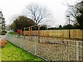
3
Garratt Green
Burntwood School is beyond.
Image: © Robin Webster
Taken: 12 May 2012
0.13 miles
4
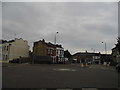
Mini roundabout on Garratt Lane
At the junction of Wimbledon Road to the left
Image: © David Howard
Taken: 29 Sep 2013
0.13 miles
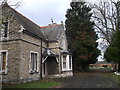
5
Diprose Lodge, Wandsworth
A Grade II listed lodge to St Clement Danes Almshouses (in the background), on Garratt Lane.
See http://www.britishlistedbuildings.co.uk/en-207043-lodge-to-st-clement-danes-almshouses-gre for more details about the lodge.
Image: © David Anstiss
Taken: 9 Dec 2012
0.14 miles
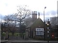
6
Disused Cemetery Lodge, Wandsworth
As seen from Garrat Lane. The lodge is within Streatham Cemetery.
Image: © David Anstiss
Taken: 9 Dec 2012
0.15 miles
7
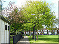
Path, Garratt Green
The bulk of the green is to the right.
Image: © Robin Webster
Taken: 12 May 2012
0.16 miles
8
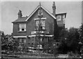
Side of the Red House, 64 Burntwood Lane, SW17
Side view of the Red House that used to be at No. 64 Burntwood Lane, Earlsfield.
Image: © William Thomas Pinnell
Taken: Unknown
0.16 miles
9
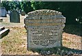
Gravestone in Garratt Green Cemetery, Earlsfield
View of Garratt Green Cemetery, showing the gravestone for William Pinnell and his wife Rose Pinnell (nee Mills), who lived in the Red House, 64 Burntwood Lane, as depicted in my other photograph. Image]
Image: © Christine Matthews
Taken: Unknown
0.18 miles
10
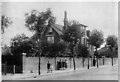
The Red House, 64 Burntwood Lane, Earlsfield, London SW17
The Red House used to be at No. 64 Burntwood Lane, Earlsfield, adjacent to Garratt Green. Following the death in 1935 of the owner, William Pinnell, Image], the house was sold. William can be seen in the picture by the gate; the other people on the pavement are his children and grandchildren. The house was demolished in the late 1930s and a block of flats was built, which is still there now Image
This photograph was taken by William Pinnell's son, William Thomas Pinnell, who was a trained photographer, who died in 1959.
Image: © William Thomas Pinnell
Taken: Unknown
0.18 miles